IMAGES TAKEN NEAR TO
Germansweek, BEAWORTHY, EX21 5AL
Introduction
This page details the photographs taken nearby to EX21 5AL by members of the Geograph project.
The Geograph project started in 2005 with the aim of publishing, organising and preserving representative images for every square kilometre of Great Britain, Ireland and the Isle of Man.

There are currently over 7.5m images from over14,400 individuals and you can help contribute to the project by visiting https://www.geograph.org.uk
Image Map (Loading...)


Getting Data...Please wait
Leaflet Map data © OpenStreetMap
Images are licensed for reuse under creativecommons.org/licenses/by-sa/2.0
Notes
- Clicking on the map will re-center to the selected point.
- The higher the marker number, the further away the image location is from the centre of the postcode.
Image Listing (3 Images Found)
Images are licensed for reuse under creativecommons.org/licenses/by-sa/2.0
Image
Details
Distance
1
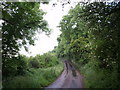
Lane near Brockscombe
The lane to the farms at Brockscombe climbs away from a tributary of the Wolf.
Image: © Derek Harper
Taken: 15 Jun 2007
0.07 miles
2
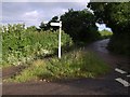
Brockscombe Cross
The lane curving round to the right has come from the A3079 and is heading towards Eworthy, somewhat circuitously. The lane to Bratton Clovelly drops steeply for a few yards to cross a tributary of the River Wolf.
Image: © Derek Harper
Taken: 15 Jun 2007
0.16 miles
3
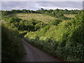
Lane below Brockscombe Cross
The view down the hill from Image as the lane drops to cross a tributary of the River Wolf. Much of the view, including most of the field of young trees on the far slope, is in SX4694.
Image: © Derek Harper
Taken: 15 Jun 2007
0.17 miles