IMAGES TAKEN NEAR TO
Studholme Place, EX2 0AY
Introduction
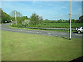
This page details the photographs taken nearby to Studholme Place, EX2 0AY by members of the Geograph project.
The Geograph project started in 2005 with the aim of publishing, organising and preserving representative images for every square kilometre of Great Britain, Ireland and the Isle of Man.

There are currently over 7.5m images from over14,400 individuals and you can help contribute to the project by visiting https://www.geograph.org.uk
Image Map
Images are licensed for reuse under creativecommons.org/licenses/by-sa/2.0
Notes
- Clicking on the map will re-center to the selected point.
- The higher the marker number, the further away the image location is from the centre of the postcode.
Image Listing (40 Images Found)
Images are licensed for reuse under creativecommons.org/licenses/by-sa/2.0
Image
Details
Distance
1
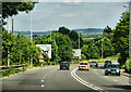
A379, Matford
Heading east towards the roundabout.
Image: © Pierre Terre
Taken: 20 Jun 2009
0.11 miles
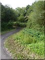
2
Foot and cycle bridge on route to Matford Roundabout
Image: © David Smith
Taken: 18 Aug 2017
0.12 miles
3
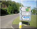
View west towards Knowle Hill from A379 roundabout
Image: © John Firth
Taken: 15 May 2010
0.14 miles
4

Matford Marsh
Another view of the more than usually flooded wetland reserve https://www.rspb.org.uk/reserves/guide/m/matfordmarsh/about.aspx , taken just after Image On the left is Basil Oak.
Image: © Derek Harper
Taken: 13 Feb 2014
0.14 miles
5

Foot and cycle bridge on Matford Marshes
Image: © David Smith
Taken: 18 Aug 2017
0.15 miles
6
Cycle racks with added green credentials
These three racks are surrounded by greenery in the form of weeds; they are provided for visitors to the wildlife reserve of Matford Marshes and seem to be underused
Image: © David Smith
Taken: 18 Aug 2017
0.15 miles
7

Matford Marsh
This water meadow is almost always partly under water, and is a RSPB reserve https://www.rspb.org.uk/reserves/guide/m/matfordmarsh/about.aspx . After the exceptional rains of the new year, the area under water has at least doubled. This view is from an X46 bus close to the Matford Park Farm roundabout. The houses are across the canal and river on Countess Wear Road.
Image: © Derek Harper
Taken: 13 Feb 2014
0.15 miles
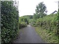
8
Road in from Knowle Hill about to join A379 Roundabout
Image: © John Firth
Taken: 15 May 2010
0.17 miles
9

Matford Marsh
Another view over the RSPB reserve shown in Image
Image: © Derek Harper
Taken: 13 Feb 2014
0.17 miles
10
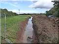
Improving the Matford Marshes nature reserve
Work in progress to create a deeper channel and pools to attract birds and other wildlife
Image: © David Smith
Taken: 18 Aug 2017
0.18 miles