IMAGES TAKEN NEAR TO
Coryton, OKEHAMPTON, EX20 4PF
Introduction
This page details the photographs taken nearby to EX20 4PF by members of the Geograph project.
The Geograph project started in 2005 with the aim of publishing, organising and preserving representative images for every square kilometre of Great Britain, Ireland and the Isle of Man.

There are currently over 7.5m images from over14,400 individuals and you can help contribute to the project by visiting https://www.geograph.org.uk
Image Map (Loading...)


Getting Data...Please wait
Leaflet Map data © OpenStreetMap
Images are licensed for reuse under creativecommons.org/licenses/by-sa/2.0
Notes
- Clicking on the map will re-center to the selected point.
- The higher the marker number, the further away the image location is from the centre of the postcode.
Image Listing (3 Images Found)
Images are licensed for reuse under creativecommons.org/licenses/by-sa/2.0
Image
Details
Distance
1

Minor road in valley of River Lew
This stretch of road is notable for the carefully maintained trees in the hedgerows on each side
Image: © David Smith
Taken: 26 Mar 2013
0.12 miles
2

Road to Knowle Farm
This minor road follows the River Lew; the farm is on the left
Image: © David Smith
Taken: 26 Mar 2013
0.18 miles
3
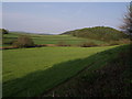
Knowle Wood
A view from the lane west of Coryton Barton. On its right (north) side, Knowle Wood drops to the River Lew. Just beyond the left edge of the wood can be seen Lee Wood, beyond the Lew and further west.
Image: © Derek Harper
Taken: 1 May 2007
0.19 miles