IMAGES TAKEN NEAR TO
Thorndon Cross, OKEHAMPTON, EX20 4NF
Introduction
This page details the photographs taken nearby to EX20 4NF by members of the Geograph project.
The Geograph project started in 2005 with the aim of publishing, organising and preserving representative images for every square kilometre of Great Britain, Ireland and the Isle of Man.

There are currently over 7.5m images from over14,400 individuals and you can help contribute to the project by visiting https://www.geograph.org.uk
Image Map
Images are licensed for reuse under creativecommons.org/licenses/by-sa/2.0
Notes
- Clicking on the map will re-center to the selected point.
- The higher the marker number, the further away the image location is from the centre of the postcode.
Image Listing (6 Images Found)
Images are licensed for reuse under creativecommons.org/licenses/by-sa/2.0
Image
Details
Distance
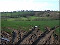
1
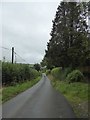
Road downhill to Thorndon from Thorndon Cross
Image: © David Smith
Taken: 21 Aug 2017
0.10 miles
3
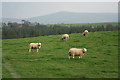
Sourton: near Thorndon Cross
Poll Dorset sheep belonging to Oatnell Farm – part of the Rossiz flock – seen with Dartmoor as a backdrop. Looking south east
Image: © Martin Bodman
Taken: 10 Oct 2007
0.15 miles
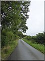
5
Sourton: near Thorndon Cross
Looking south-south-east with the Dartmoor hills on the skyline
Image: © Martin Bodman
Taken: 8 Jul 2006
0.21 miles
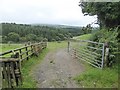
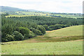
6
Near Thorndon Cross
A view across the valley of a tributary of the River Thrushel, from the lane between Thorndon and Thorndon Cross. The maps are out of date - the two nearest field boundaries on the left are not shown, but appear clearly on live.com. The ridge beyond is Thorndon Down.
Image: © Derek Harper
Taken: 10 Mar 2007
0.21 miles