IMAGES TAKEN NEAR TO
Tanners Hill, OKEHAMPTON, EX20 4ND
Introduction
This page details the photographs taken nearby to Tanners Hill, EX20 4ND by members of the Geograph project.
The Geograph project started in 2005 with the aim of publishing, organising and preserving representative images for every square kilometre of Great Britain, Ireland and the Isle of Man.

There are currently over 7.5m images from over14,400 individuals and you can help contribute to the project by visiting https://www.geograph.org.uk
Image Map
Images are licensed for reuse under creativecommons.org/licenses/by-sa/2.0
Notes
- Clicking on the map will re-center to the selected point.
- The higher the marker number, the further away the image location is from the centre of the postcode.
Image Listing (3 Images Found)
Images are licensed for reuse under creativecommons.org/licenses/by-sa/2.0
Image
Details
Distance
1
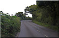
A3079 Holsworthy Road towards Thorndon Cross
Image: © J.Hannan-Briggs
Taken: 31 Jul 2014
0.06 miles
2
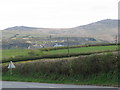
Fields by the A3079
Dartmoor can be seen in the distance.
Image: © Sarah Charlesworth
Taken: 28 Apr 2010
0.09 miles
3

Bridge at Yelland
The stream flows into the River Yew to the north
Image: © David Smith
Taken: 23 Jun 2016
0.24 miles