IMAGES TAKEN NEAR TO
Tavistock Road, OKEHAMPTON, EX20 4LR
Introduction
This page details the photographs taken nearby to Tavistock Road, EX20 4LR by members of the Geograph project.
The Geograph project started in 2005 with the aim of publishing, organising and preserving representative images for every square kilometre of Great Britain, Ireland and the Isle of Man.

There are currently over 7.5m images from over14,400 individuals and you can help contribute to the project by visiting https://www.geograph.org.uk
Image Map
Images are licensed for reuse under creativecommons.org/licenses/by-sa/2.0
Notes
- Clicking on the map will re-center to the selected point.
- The higher the marker number, the further away the image location is from the centre of the postcode.
Image Listing (4 Images Found)
Images are licensed for reuse under creativecommons.org/licenses/by-sa/2.0
Image
Details
Distance


3

The Betty Cottles Inn, on the outskirts of Okehampton
Image: © David Gearing
Taken: 12 May 2014
0.15 miles
4
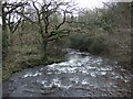
West Okement River
The river, looking downstream, seen from a bridge carrying the road which the climbs the valley to Meldon Viaduct. Curiously, two parallel bridleways (Okehampton Hamlets Bridleways 30 and 41) both cross the bridge.
Image: © Derek Harper
Taken: 25 Feb 2007
0.17 miles