IMAGES TAKEN NEAR TO
Bratton Clovelly, OKEHAMPTON, EX20 4JT
Introduction
This page details the photographs taken nearby to EX20 4JT by members of the Geograph project.
The Geograph project started in 2005 with the aim of publishing, organising and preserving representative images for every square kilometre of Great Britain, Ireland and the Isle of Man.

There are currently over 7.5m images from over14,400 individuals and you can help contribute to the project by visiting https://www.geograph.org.uk
Image Map
Images are licensed for reuse under creativecommons.org/licenses/by-sa/2.0
Notes
- Clicking on the map will re-center to the selected point.
- The higher the marker number, the further away the image location is from the centre of the postcode.
Image Listing (9 Images Found)
Images are licensed for reuse under creativecommons.org/licenses/by-sa/2.0
Image
Details
Distance

2

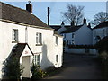
Bratton Clovelly
A jumble of roofs in the main village street. The village has great charm.
Image: © Derek Harper
Taken: 10 Mar 2007
0.09 miles
3
Bratton Clovelly
Looking along the village street, between the pub and the church.
Image: © Derek Harper
Taken: 10 Mar 2007
0.09 miles
4

Clovelly Inn
A very nice spot to visit, (the fireplace is a must see).
Image: © Steve Barnes
Taken: 7 Apr 2012
0.10 miles
5
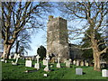
St Mary's church, Bratton Clovelly
"The church poses some architectural problems", say Cherry & Pevsner; different building periods are apparent in the west tower, for instance. Anyway, its battlements make it an impressive and dominant feature of this attractive village. Seen here from the southwest part of the sloping churchyard.
Image: © Derek Harper
Taken: 10 Mar 2007
0.12 miles
6

Ordnance Survey Cut Mark
This OS cut mark can be found on St Mary's Church. It marks a point 178.338m above mean sea level.
Image: © Adrian Dust
Taken: 18 Feb 2014
0.12 miles
7

Gravestone, Bratton Clovelly
In St Mary's churchyard. A glimpse of the moor in the distance; a churchyard that is both pretty and possesses fine views.
Image: © Derek Harper
Taken: 10 Mar 2007
0.12 miles
8

Lane north of Bratton Clovelly
The lane (which leads to Voulsdon Cross) drops away down the northern slope of the hill on which the village stands, past Tugela, a brick house named after the South African river by a Boer War survivor.
Image: © Derek Harper
Taken: 10 Mar 2007
0.14 miles
9
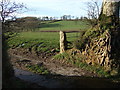
Gateway north of Bratton Clovelly
This gateway can be seen on the left in Image Beech roots and an old gatepost beside a view across the shallow valley of a tributary of the Breazle Water.
Image: © Derek Harper
Taken: 10 Mar 2007
0.25 miles