IMAGES TAKEN NEAR TO
Sourton Down, OKEHAMPTON, EX20 4HR
Introduction
This page details the photographs taken nearby to EX20 4HR by members of the Geograph project.
The Geograph project started in 2005 with the aim of publishing, organising and preserving representative images for every square kilometre of Great Britain, Ireland and the Isle of Man.

There are currently over 7.5m images from over14,400 individuals and you can help contribute to the project by visiting https://www.geograph.org.uk
Image Map (Loading...)


Getting Data...Please wait
Leaflet Map data © OpenStreetMap
Images are licensed for reuse under creativecommons.org/licenses/by-sa/2.0
Notes
- Clicking on the map will re-center to the selected point.
- The higher the marker number, the further away the image location is from the centre of the postcode.
Image Listing (39 Images Found)
Images are licensed for reuse under creativecommons.org/licenses/by-sa/2.0
Image
Details
Distance
1

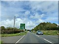
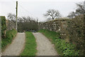
Former route of A386
This is the route of the A386 prior to the construction of the dual carriageway A30 and the junction at Sourton. It is a cul-de-sac giving access to houses and a caravan park
Image: © David Smith
Taken: 2 Nov 2012
0.04 miles
2
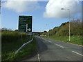
Approaching Sourton Cross
On the A386 heading towards Okehampton.
Image: © Andrew Abbott
Taken: 24 Sep 2019
0.04 miles
4

Once the main line
Former LSWR route from Waterloo to Plymouth closed may 1968 now a cycle path.Quite overgrown now compared to when the railway was open.
Image: © roger geach
Taken: 31 Mar 2012
0.05 miles
5
Bridge over disused railway
See also Image, taken from virtually the same position.
Image: © MrC
Taken: Unknown
0.06 miles
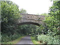
6

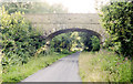
Granite Way at Sourton Down
A side path gives access to and from the cycleway. The bridge carries the road to Prewley Farm across the former railway track.
Image: © Derek Harper
Taken: 26 Oct 2007
0.06 miles
7

Farm access bridge crossing Granite Way
Image: © David Smith
Taken: 19 Feb 2020
0.07 miles
8
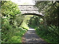
Bridge over the Cycle Track
This solidly built bridge, originally constructed when the railway line was built, takes nothing more than a private track to a moorland edge farm.
Image: © Tony Atkin
Taken: 2 Sep 2014
0.07 miles
9
Former railway overbridge
Now carrying the farm access road over a cycleway rather than the once main LSWR to Plymouth.
Image: © roger geach
Taken: 31 Mar 2012
0.07 miles
10
Meldon Disused Railway
Bridge over the disused section of Meldon Railway. Further on is Meldon Viaduct and the preserved steam railway.
Image: © Susan Buck
Taken: 16 Aug 2006
0.08 miles