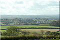
IMAGES TAKEN NEAR TO
Exbourne, OKEHAMPTON, EX20 3SG
Introduction
This page details the photographs taken nearby to EX20 3SG by members of the Geograph project.
The Geograph project started in 2005 with the aim of publishing, organising and preserving representative images for every square kilometre of Great Britain, Ireland and the Isle of Man.

There are currently over 7.5m images from over14,400 individuals and you can help contribute to the project by visiting https://www.geograph.org.uk
Image Map
Images are licensed for reuse under creativecommons.org/licenses/by-sa/2.0
Notes
- Clicking on the map will re-center to the selected point.
- The higher the marker number, the further away the image location is from the centre of the postcode.
Image Listing (15 Images Found)
Images are licensed for reuse under creativecommons.org/licenses/by-sa/2.0
Image
Details
Distance


3
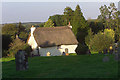
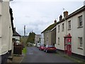
Church Cottage and churchyard, Exbourne
Image: © Jeremy Holland
Taken: 18 Sep 2008
0.07 miles
4
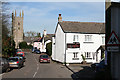
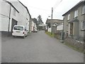
Exbourne: the village
The Red Lion – ‘under new management’ early in 2007 – on the right with Exbourne church beyond. Dedicated to St Mary, its tower is of Dartmoor granite, with set-back buttresses. It is also noted for its rood screen dating from circa 1425. Looking north
Image: © Martin Bodman
Taken: 4 Feb 2007
0.08 miles

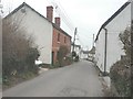
9
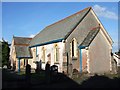
Exbourne Methodist Church
The church is on Fore Street, which leads from the village centre down towards the Hole Brook valley.
Image: © Derek Harper
Taken: 12 Jun 2007
0.12 miles