IMAGES TAKEN NEAR TO
Ashbury, OKEHAMPTON, EX20 3PE
Introduction
This page details the photographs taken nearby to Ashbury, EX20 3PE by members of the Geograph project.
The Geograph project started in 2005 with the aim of publishing, organising and preserving representative images for every square kilometre of Great Britain, Ireland and the Isle of Man.

There are currently over 7.5m images from over14,400 individuals and you can help contribute to the project by visiting https://www.geograph.org.uk
Image Map
Images are licensed for reuse under creativecommons.org/licenses/by-sa/2.0
Notes
- Clicking on the map will re-center to the selected point.
- The higher the marker number, the further away the image location is from the centre of the postcode.
Image Listing (5 Images Found)
Images are licensed for reuse under creativecommons.org/licenses/by-sa/2.0
Image
Details
Distance
1
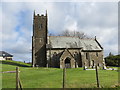
The Church of St Mary at Ashbury
Viewed from the south.
Image: © Peter Wood
Taken: 31 Mar 2015
0.03 miles
2
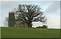
St Mary?s church, Ashbury
The church, of which only the "unusually late tower" (C16/C17) pre-dates a total rebuild in the 1870s, is described at http://www.britishlistedbuildings.co.uk/en-94247-church-of-st-mary-northlew . See also Image
Image: © Derek Harper
Taken: 20 Jan 2012
0.04 miles
3

Ashbury: St Mary?s church
Looking east-north-east
Image: © Martin Bodman
Taken: 8 Jul 2006
0.04 miles
4
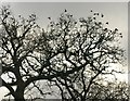
Starlings, Ashbury
Gathering in an oak tree south of the hamlet.
Image: © Derek Harper
Taken: 20 Jan 2012
0.12 miles
5
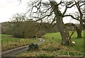
Lane into the Lew valley
The lane from Ashbury drops down towards Kennel Bridge over the Lew.
Image: © Derek Harper
Taken: 20 Jan 2012
0.15 miles