IMAGES TAKEN NEAR TO
Hatherleigh, OKEHAMPTON, EX20 3LS
Introduction
This page details the photographs taken nearby to EX20 3LS by members of the Geograph project.
The Geograph project started in 2005 with the aim of publishing, organising and preserving representative images for every square kilometre of Great Britain, Ireland and the Isle of Man.

There are currently over 7.5m images from over14,400 individuals and you can help contribute to the project by visiting https://www.geograph.org.uk
Image Map
Images are licensed for reuse under creativecommons.org/licenses/by-sa/2.0
Notes
- Clicking on the map will re-center to the selected point.
- The higher the marker number, the further away the image location is from the centre of the postcode.
Image Listing (9 Images Found)
Images are licensed for reuse under creativecommons.org/licenses/by-sa/2.0
Image
Details
Distance

2
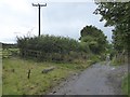
Track to Essworthy with field entrance
Part of the entrance is blocked by what remains of a roller made of stone
Image: © David Smith
Taken: 18 Sep 2017
0.07 miles
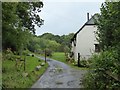
6
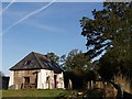
Cottage at Essworthy
An interesting new building at Lower Essworthy, seen from Hatherleigh Bridleway 8.
Image: © Derek Harper
Taken: 4 Oct 2007
0.10 miles
7
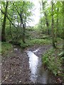
Stream that is a tributary of the Lew in woods south of Essworthy
Image: © David Smith
Taken: 18 Sep 2017
0.17 miles
8
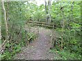
Footbridges in the woods south of Essworthy
Image: © David Smith
Taken: 18 Sep 2017
0.22 miles
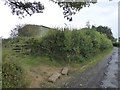
9
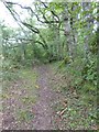
Bridleway and hedgebanks south of Essworthy
Image: © David Smith
Taken: 18 Sep 2017
0.23 miles