IMAGES TAKEN NEAR TO
Holsworthy Road, OKEHAMPTON, EX20 3LR
Introduction
This page details the photographs taken nearby to Holsworthy Road, EX20 3LR by members of the Geograph project.
The Geograph project started in 2005 with the aim of publishing, organising and preserving representative images for every square kilometre of Great Britain, Ireland and the Isle of Man.

There are currently over 7.5m images from over14,400 individuals and you can help contribute to the project by visiting https://www.geograph.org.uk
Image Map (Loading...)


Getting Data...Please wait
Leaflet Map data © OpenStreetMap
Images are licensed for reuse under creativecommons.org/licenses/by-sa/2.0
Notes
- Clicking on the map will re-center to the selected point.
- The higher the marker number, the further away the image location is from the centre of the postcode.
Image Listing (13 Images Found)
Images are licensed for reuse under creativecommons.org/licenses/by-sa/2.0
Image
Details
Distance


3

Green bus shelter, A3072, Hatherleigh
This shelter serves an estate about half a mile from the centre of Hatherleigh; why paint it green?
Image: © David Smith
Taken: 14 Apr 2016
0.14 miles
4

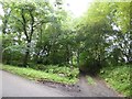
Construction of a new home near Hatchmoor
Image: © David Smith
Taken: 21 Aug 2017
0.18 miles

7

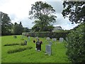
Gates of Hatherleigh Methodist Cemetery
Image: © David Smith
Taken: 21 Aug 2017
0.20 miles
9
Secondary entrance to Passaford
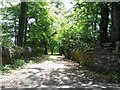
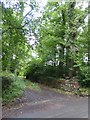
There is an approach avenue to Passaford from this track through Westpark Plantation. Most traffic for Passaford approaches it from another road
Image: © David Smith
Taken: 21 Aug 2017
0.22 miles