IMAGES TAKEN NEAR TO
Holsworthy Road, OKEHAMPTON, EX20 3LE
Introduction
This page details the photographs taken nearby to Holsworthy Road, EX20 3LE by members of the Geograph project.
The Geograph project started in 2005 with the aim of publishing, organising and preserving representative images for every square kilometre of Great Britain, Ireland and the Isle of Man.

There are currently over 7.5m images from over14,400 individuals and you can help contribute to the project by visiting https://www.geograph.org.uk
Image Map
Images are licensed for reuse under creativecommons.org/licenses/by-sa/2.0
Notes
- Clicking on the map will re-center to the selected point.
- The higher the marker number, the further away the image location is from the centre of the postcode.
Image Listing (4 Images Found)
Images are licensed for reuse under creativecommons.org/licenses/by-sa/2.0
Image
Details
Distance

3

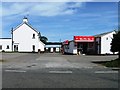
Lay-by west of Hatherleigh on A3072
A very short lay-by on a bend in the main road
Image: © David Smith
Taken: 14 Apr 2016
0.18 miles
4
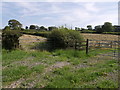
Hay fields beside the A3072
New mown hay lying in fields on the slopes below Hannaborough, about a miles outside Hatherleigh on the road to Holsworthy.
Image: © Derek Harper
Taken: 23 Aug 2007
0.21 miles