IMAGES TAKEN NEAR TO
Glebe Close, OKEHAMPTON, EX20 3GD
Introduction
This page details the photographs taken nearby to Glebe Close, EX20 3GD by members of the Geograph project.
The Geograph project started in 2005 with the aim of publishing, organising and preserving representative images for every square kilometre of Great Britain, Ireland and the Isle of Man.

There are currently over 7.5m images from over14,400 individuals and you can help contribute to the project by visiting https://www.geograph.org.uk
Image Map
Images are licensed for reuse under creativecommons.org/licenses/by-sa/2.0
Notes
- Clicking on the map will re-center to the selected point.
- The higher the marker number, the further away the image location is from the centre of the postcode.
Image Listing (57 Images Found)
Images are licensed for reuse under creativecommons.org/licenses/by-sa/2.0
Image
Details
Distance
1

Old Milestone by Oakfield Road, Hatherleigh parish
Carved stone post by the UC road, in parish of HATHERLEIGH (WEST DEVON District), Oakfield Road (Old Torrington Road), opposite Old Vicarage, 30m South of Church Lane, part embedded in bank, down from Turnpike Lane/Sanctuary Road crossing, on East side of road. Torrington tombstone, erected by the Great Torrington turnpike trust in the 18th century.
Inscription reads:-
TO
TORRINGTON
12
MILES
Milestone Society National ID: DV_GTHA12
Image: © Alan Rosevear
Taken: 18 Feb 2013
0.11 miles
3
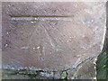
Ordnance Survey PA Bolt
This OS PA Bolt can be found on the church. It marks a point 87.584m above mean sea level.
Image: © Adrian Dust
Taken: 18 Feb 2014
0.14 miles
5
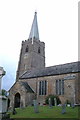
Hatherleigh: St John the Baptist?s church
View south with Dartmoor just visible in the distance. Red sandstone forms the bulk of the structure, which dates from the 15th century
Image: © Martin Bodman
Taken: 8 Feb 2006
0.14 miles
6

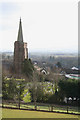
Hatherleigh: towards Strawbridge
Farmland north west of the town
Image: © Martin Bodman
Taken: 8 Feb 2006
0.14 miles

8
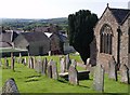
Churchyard, Hatherleigh
On the right is Image The path crosses the sloping churchyard linking Church Lane with the square, a few yards beyond the gate. The roof and bell cote of Image can be seen.
Image: © Derek Harper
Taken: 23 Aug 2007
0.15 miles

