IMAGES TAKEN NEAR TO
Merton, OKEHAMPTON, EX20 3EA
Introduction
This page details the photographs taken nearby to EX20 3EA by members of the Geograph project.
The Geograph project started in 2005 with the aim of publishing, organising and preserving representative images for every square kilometre of Great Britain, Ireland and the Isle of Man.

There are currently over 7.5m images from over14,400 individuals and you can help contribute to the project by visiting https://www.geograph.org.uk
Image Map
Images are licensed for reuse under creativecommons.org/licenses/by-sa/2.0
Notes
- Clicking on the map will re-center to the selected point.
- The higher the marker number, the further away the image location is from the centre of the postcode.
Image Listing (13 Images Found)
Images are licensed for reuse under creativecommons.org/licenses/by-sa/2.0
Image
Details
Distance


4
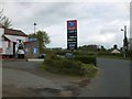
Post office, shop and filling station, Merton
Image: © David Smith
Taken: 9 May 2013
0.07 miles

8

Stone cross (weathered)
Slightly mysterious; this is outside the Clinton Hall and village school, but is not included in the village's listed buildings, nor in an extensive list of county crosses.
Image: © David Smith
Taken: 9 May 2013
0.17 miles
9
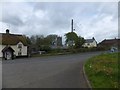
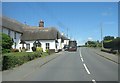
Thatched house and village buildings by A386 in Merton
Image: © David Smith
Taken: 9 May 2013
0.17 miles