IMAGES TAKEN NEAR TO
Merton, OKEHAMPTON, EX20 3DS
Introduction
This page details the photographs taken nearby to EX20 3DS by members of the Geograph project.
The Geograph project started in 2005 with the aim of publishing, organising and preserving representative images for every square kilometre of Great Britain, Ireland and the Isle of Man.

There are currently over 7.5m images from over14,400 individuals and you can help contribute to the project by visiting https://www.geograph.org.uk
Image Map (Loading...)


Getting Data...Please wait
Leaflet Map data © OpenStreetMap
Images are licensed for reuse under creativecommons.org/licenses/by-sa/2.0
Notes
- Clicking on the map will re-center to the selected point.
- The higher the marker number, the further away the image location is from the centre of the postcode.
Image Listing (9 Images Found)
Images are licensed for reuse under creativecommons.org/licenses/by-sa/2.0
Image
Details
Distance
1
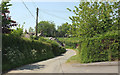
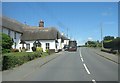
Lane at Merton
Leading from Merton Mill and entering the village past cottages.
Image: © Derek Harper
Taken: 23 May 2018
0.04 miles

3
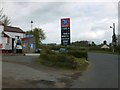
Post office, shop and filling station, Merton
Image: © David Smith
Taken: 9 May 2013
0.09 miles
4
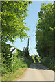
Lane to Merton Mill
Looking in the opposite direction from where Image] was taken.
Image: © Derek Harper
Taken: 23 May 2018
0.09 miles
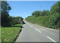


9
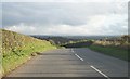
A386 by Newberry Farm
Approaching the turning on the left for Merton House.
Image: © Fernweh
Taken: 28 Oct 2015
0.21 miles