IMAGES TAKEN NEAR TO
Folly Gate, OKEHAMPTON, EX20 3AD
Introduction
This page details the photographs taken nearby to EX20 3AD by members of the Geograph project.
The Geograph project started in 2005 with the aim of publishing, organising and preserving representative images for every square kilometre of Great Britain, Ireland and the Isle of Man.

There are currently over 7.5m images from over14,400 individuals and you can help contribute to the project by visiting https://www.geograph.org.uk
Image Map
Images are licensed for reuse under creativecommons.org/licenses/by-sa/2.0
Notes
- Clicking on the map will re-center to the selected point.
- The higher the marker number, the further away the image location is from the centre of the postcode.
Image Listing (9 Images Found)
Images are licensed for reuse under creativecommons.org/licenses/by-sa/2.0
Image
Details
Distance
1

Inwardleigh: Folly Gate
The Crossways Inn. Looking north west
Image: © Martin Bodman
Taken: 16 Jul 2006
0.08 miles

3

Commemoration stone for RAF Folly Gate
This stone stands in front of the only surviving building from the airfield, also known RAF Okehampton II. It operated from 1928 to 1960 http://www.abct.org.uk/airfields/okehampton-ii-folly-gate
Image: © David Smith
Taken: 9 May 2013
0.10 miles
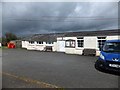
4

Bus stop and shelter in Folly Gate
Opposite the shelter is a stone commemorating RAF Folly Gate
Image: © David Smith
Taken: 9 May 2013
0.10 miles
5
Folly Gate Village Hall, a WW2 building used by the WAAF
According to http://www.abct.org.uk/airfields/okehampton-ii-folly-gate "The [RAF Folly Gate] airfield remains tangible today, mainly through a building formerly used by the Women's Auxiliary Air Force, now serving as Folly Gate Village Hall."
Image: © David Smith
Taken: 9 May 2013
0.10 miles
6
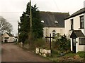
Folly Gate
The lane leading west from the Crossways Inn passes the former chapel, now a private house.
Image: © Derek Harper
Taken: 20 Jan 2012
0.10 miles
7
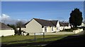
Bungalows, New Road estate, Folly Gate
The estate consists of about twenty houses and bungalows fronting, or on a crescent leading from, the A386
Image: © David Smith
Taken: 14 Apr 2016
0.13 miles
8
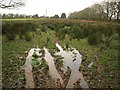
Rushy meadow, Folly Gate
A soggy entrance into this field by the double bend in the lane east of Folly Gate.
Image: © Derek Harper
Taken: 20 Jan 2012
0.14 miles
9
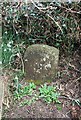
Old Milestone off the A386, Five Oaks, near Folly Gate
Carved stone post by the UC road (was A386), in parish of Inwardleigh (West Devon District), Five Oaks, on an old loop of the road opposite New Road Estate, at Folly Gate, on hedge bank, on East side of road. Okehampton small tombstone, erected by the Okehampton turnpike trust in the 18th century.
Inscription reads:-
OKETON
2
Miles
Milestone Society National ID: DV_OKFG02
Image: © A Rosevear
Taken: 27 Feb 2012
0.18 miles