IMAGES TAKEN NEAR TO
Sampford Courtenay, OKEHAMPTON, EX20 2TH
Introduction
This page details the photographs taken nearby to EX20 2TH by members of the Geograph project.
The Geograph project started in 2005 with the aim of publishing, organising and preserving representative images for every square kilometre of Great Britain, Ireland and the Isle of Man.

There are currently over 7.5m images from over14,400 individuals and you can help contribute to the project by visiting https://www.geograph.org.uk
Image Map (Loading...)


Getting Data...Please wait
Leaflet Map data © OpenStreetMap
Images are licensed for reuse under creativecommons.org/licenses/by-sa/2.0
Notes
- Clicking on the map will re-center to the selected point.
- The higher the marker number, the further away the image location is from the centre of the postcode.
Image Listing (5 Images Found)
Images are licensed for reuse under creativecommons.org/licenses/by-sa/2.0
Image
Details
Distance
1
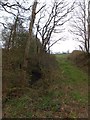
Track to a field at Underdown Moor
The track starts at the bridge Image] on the minor road to Sampford Courtenay
Image: © David Smith
Taken: 25 Apr 2013
0.11 miles
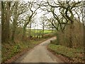
2
Bridge at Underdown Moor
The stream runs through a wooded valley; Image] shows the view from the opposite side
Image: © David Smith
Taken: 25 Apr 2013
0.11 miles
3

Bridge at Underdown Moor
The stream runs through a wooded valley
Image: © David Smith
Taken: 25 Apr 2013
0.11 miles
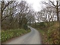
4
Lane at Underdown Moor
The lane shown in Image crosses a small stream, a tributary of the Hole Brook, at this bend. On the right, a small wood follows the stream.
Image: © Derek Harper
Taken: 20 Jan 2012
0.12 miles
5
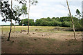
Sampford Courtenay: near Youldon Bridge
Felled trees and saplings in a field by the Hole Brook. Looking east-south-east
Image: © Martin Bodman
Taken: 27 Jul 2006
0.24 miles