IMAGES TAKEN NEAR TO
Sampford Courtenay, OKEHAMPTON, EX20 2SR
Introduction
This page details the photographs taken nearby to EX20 2SR by members of the Geograph project.
The Geograph project started in 2005 with the aim of publishing, organising and preserving representative images for every square kilometre of Great Britain, Ireland and the Isle of Man.

There are currently over 7.5m images from over14,400 individuals and you can help contribute to the project by visiting https://www.geograph.org.uk
Image Map (Loading...)


Getting Data...Please wait
Leaflet Map data © OpenStreetMap
Images are licensed for reuse under creativecommons.org/licenses/by-sa/2.0
Notes
- Clicking on the map will re-center to the selected point.
- The higher the marker number, the further away the image location is from the centre of the postcode.
Image Listing (10 Images Found)
Images are licensed for reuse under creativecommons.org/licenses/by-sa/2.0
Image
Details
Distance
4
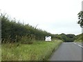
Cartoon thanking NHS by B3215 during Covid-19 pandemic
Image: © David Smith
Taken: 2 Sep 2020
0.13 miles
5
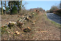
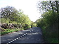
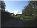
Sampford Courtenay: recent hedging
On the road from Okehampton, the B3215. Looking north east
Image: © Martin Bodman
Taken: 19 Mar 2006
0.16 miles
8
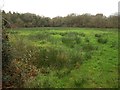
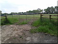
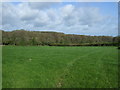
Rushy field by the B3215
Taken from a gateway just up the hill shown in Image, looking left. The field is surrounded on three sides by woodland.
Image: © Derek Harper
Taken: 20 Jan 2012
0.19 miles