IMAGES TAKEN NEAR TO
Addiscott, OKEHAMPTON, EX20 2RE
Introduction
This page details the photographs taken nearby to Addiscott, EX20 2RE by members of the Geograph project.
The Geograph project started in 2005 with the aim of publishing, organising and preserving representative images for every square kilometre of Great Britain, Ireland and the Isle of Man.

There are currently over 7.5m images from over14,400 individuals and you can help contribute to the project by visiting https://www.geograph.org.uk
Image Map
Images are licensed for reuse under creativecommons.org/licenses/by-sa/2.0
Notes
- Clicking on the map will re-center to the selected point.
- The higher the marker number, the further away the image location is from the centre of the postcode.
Image Listing (23 Images Found)
Images are licensed for reuse under creativecommons.org/licenses/by-sa/2.0
Image
Details
Distance
1
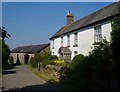
Addiscott Home Farm
Farmhouse and barn conversion, seen from the other direction in Image
Image: © Derek Harper
Taken: 8 Jun 2006
0.01 miles
2
Addiscott
Addiscott Home Farm, and a row of cottages, from the lane to Oxenham Manor. Image shows the reverse view.
Image: © Derek Harper
Taken: 8 Jun 2006
0.01 miles
3
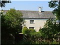
Farmhouse at Addiscott
Moore's Addiscott is set at right angles to the lane from Fire Stone Cross.
Image: © Derek Harper
Taken: 8 Jun 2006
0.03 miles
4
Moore's Addiscott
Another view, from Addiscott Cross, of the farmhouse shown in Image
Image: © Derek Harper
Taken: 8 Jun 2006
0.03 miles
5
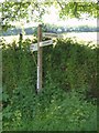
Addiscott Cross
The signpost is in deep shadow, with a brightly sunny field behind. An exuberant nettle has partly obscured "Whiddon Down".
Image: © Derek Harper
Taken: 8 Jun 2006
0.03 miles
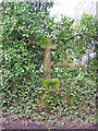
6
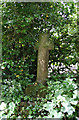
Old Wayside Cross at Addiscott
Addiscott Cross, old head, shaft and base, Starkey No.63 by the UC road, in parish of South Tawton (West Devon District), just West of the crossroads, opposite Addiscott Farm, in the bank, under trees.
Grade II listed.
List Entry Number: 1170174 https://historicengland.org.uk/listing/the-list/list-entry/1170174
Surveyed
Milestone Society National ID: DVWD_STA01
Image: © Alan Rosevear
Taken: 19 Jun 2009
0.04 miles
8
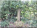
Stone cross at Addiscott
According to http://www.dartmoor-crosses.org.uk/addiscott.htm this was a waymarker for travellers going to the church at South Tawton
Image: © David Smith
Taken: 12 Oct 2011
0.05 miles
9
Addiscott Cross
The cross is located at the crossroads beside Adiscott Farm. This cross has been moved a couple of times in the past, but thankfully not far. During the 1870s it was moved from its original site in order to make way for a gateway to be created. It appears that its new site was not ideal and in 1958 it was moved again to its current site. Luckily it has been cared for during these moves and has not suffered the fate of a number of Dartmoor Crosses, which have had their arms knocked off and been used as gateposts in similar circumstances.
Image: © Richard Dorrell
Taken: 23 Mar 2010
0.05 miles
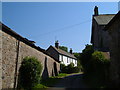
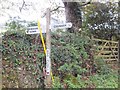
10
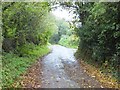
Minor road to Dishcombe from Addiscott
Image: © David Smith
Taken: 12 Oct 2011
0.05 miles