IMAGES TAKEN NEAR TO
South Tawton, OKEHAMPTON, EX20 2RA
Introduction
This page details the photographs taken nearby to EX20 2RA by members of the Geograph project.
The Geograph project started in 2005 with the aim of publishing, organising and preserving representative images for every square kilometre of Great Britain, Ireland and the Isle of Man.

There are currently over 7.5m images from over14,400 individuals and you can help contribute to the project by visiting https://www.geograph.org.uk
Image Map
Images are licensed for reuse under creativecommons.org/licenses/by-sa/2.0
Notes
- Clicking on the map will re-center to the selected point.
- The higher the marker number, the further away the image location is from the centre of the postcode.
Image Listing (4 Images Found)
Images are licensed for reuse under creativecommons.org/licenses/by-sa/2.0
Image
Details
Distance
1
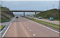
West Devon : The A30
The A30 heading through the county of Devon towards Cornwall.
Image: © Lewis Clarke
Taken: 23 Feb 2014
0.22 miles
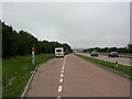
3
A30 from Ringhill Cross
The dual carriageway within a grassy cutting colonised by gorse. Image is some 30 metres behind the camera.
Image: © Derek Harper
Taken: 8 Jun 2006
0.23 miles
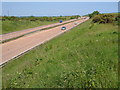
4

A30 from Ringhill Cross
The weather forecast led me to expect a summer solstice with weather similar to Image, and so it eventually turned out, but there was a lot of cloud around and even some rain for a couple of hours or more.
Image: © Derek Harper
Taken: 21 Jun 2019
0.23 miles