IMAGES TAKEN NEAR TO
South Zeal, OKEHAMPTON, EX20 2QB
Introduction
This page details the photographs taken nearby to EX20 2QB by members of the Geograph project.
The Geograph project started in 2005 with the aim of publishing, organising and preserving representative images for every square kilometre of Great Britain, Ireland and the Isle of Man.

There are currently over 7.5m images from over14,400 individuals and you can help contribute to the project by visiting https://www.geograph.org.uk
Image Map
Images are licensed for reuse under creativecommons.org/licenses/by-sa/2.0
Notes
- Clicking on the map will re-center to the selected point.
- The higher the marker number, the further away the image location is from the centre of the postcode.
Image Listing (17 Images Found)
Images are licensed for reuse under creativecommons.org/licenses/by-sa/2.0
Image
Details
Distance
1
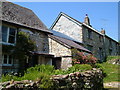
Cottages at East Week
Renovated cottages on the short sharp hill up to the big farm at East Week. The further building rejoices in the name of "Pumpy Cottage".
Image: © Derek Harper
Taken: 8 Jun 2006
0.02 miles
2
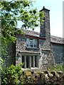
Cottage, East Week
A C17 4-light mullion window (with a central king mullion) and tall stack on the facade of this cottage http://www.britishlistedbuildings.co.uk/en-94990-east-week-cottages-3-south-tawton .
Image: © Derek Harper
Taken: 8 Jun 2006
0.02 miles
3

East Week from Cosdon Hill
The view from South Tawton Bridleway 21, looking more to the right than Image
Image: © Derek Harper
Taken: 8 Jun 2006
0.02 miles
4

Blackaton Brook
Looking downstream from the Mariner's Way on South Tawton Footpath 45 near East Week.
Image: © Derek Harper
Taken: 8 Jun 2006
0.04 miles
5
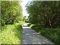
Lane to East Week
Running close to the Blackaton Brook and with a small area of access woodland on the right.
Image: © Derek Harper
Taken: 8 Jun 2006
0.07 miles
6

Middle Week
A view of some of the buildings shown in Image, from the same spot. Beyond are fields and countryside around the Blackaton Brook valley (in Image) as the stream emerges from the moor.
Image: © Derek Harper
Taken: 8 Jun 2006
0.10 miles
7
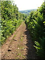
Green lane near East Week
Linking the public roads at High Week and East Week, this route with public access is gently descending to the latter. In the distance is a glimpse of the moor's edge at Clannaborough.
Image: © Derek Harper
Taken: 8 Jun 2006
0.11 miles
8
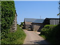
Farm buildings at East Week
The further building is a "Workshop, former farmhouse ... Early C17" http://www.britishlistedbuildings.co.uk/en-94988-workshop-approximately-80-metres-south-we .
Image: © Derek Harper
Taken: 8 Jun 2006
0.12 miles
9
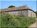
Farm buildings at East Week
Opposite those shown in Image, these form two sides of the farmyard.
Image: © Derek Harper
Taken: 8 Jun 2006
0.12 miles
10
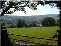
Middle Week
A glimpse of the farm from a bend (shown in Image]) in the green lane between East Week and South Tawton; Dartmoor in the background.
Image: © Derek Harper
Taken: 8 Jun 2006
0.13 miles