IMAGES TAKEN NEAR TO
Sticklepath, OKEHAMPTON, EX20 2NS
Introduction
This page details the photographs taken nearby to EX20 2NS by members of the Geograph project.
The Geograph project started in 2005 with the aim of publishing, organising and preserving representative images for every square kilometre of Great Britain, Ireland and the Isle of Man.

There are currently over 7.5m images from over14,400 individuals and you can help contribute to the project by visiting https://www.geograph.org.uk
Image Map
Images are licensed for reuse under creativecommons.org/licenses/by-sa/2.0
Notes
- Clicking on the map will re-center to the selected point.
- The higher the marker number, the further away the image location is from the centre of the postcode.
Image Listing (7 Images Found)
Images are licensed for reuse under creativecommons.org/licenses/by-sa/2.0
Image
Details
Distance
1

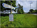
New houses on the old A30, near Sticklepath
Image: © Rob Purvis
Taken: 27 May 2018
0.07 miles

3
Road sign on the old A30 near Sticklepath, looking east
Image: © Rob Purvis
Taken: 27 May 2018
0.09 miles
4
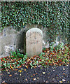
Old Milestone by former A30, South Tawton parish
Carved stone post by the UC road (was A30), in parish of South Tawton (West Devon District), by drive of Trafalgar House, South end of Sticklepath, against wall beside entrance drive to house, on East side of road. Okehampton tombstone, erected by the Okehampton turnpike trust in the 18th century.
Inscription reads:-
OKEHAMPTON
4
MILES
Devon & Dartmoor HER.
HER Number: MDV59512 https://www.heritagegateway.org.uk/Gateway/Results_Single.aspx?uid=MDV59512&resourceID=104
Milestone Society National ID: DV_EXOK18
Image: © Alan Rosevear
Taken: 22 Oct 2008
0.13 miles
5

Sticklepath Quaker Burying Ground
The summer house.
Image: © Ian James Cox
Taken: 2 Sep 2009
0.21 miles
6

Old Boundary Marker near Hopedene, Sticklepath parish
Parish Boundary Marker by the UC (was A30), in parish of Sticklepath (West Devon District), 10m up from "Hopedene" on bend, in bank under hedge, East side of road.
Inscription reads:-
ST
S
Devon & Dartmoor HER.
HER Number: MDV71864 https://www.heritagegateway.org.uk/Gateway/Results_Single.aspx?uid=MDV71864&resourceID=104
Surveyed
Milestone Society National ID: DV_LAEX19bpb
Image: © Alan Rosevear
Taken: 13 Mar 2013
0.22 miles
7
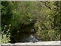
The view upstream from Sticklepath Bridge on the river Taw
Image: © Roger A Smith
Taken: 5 May 2010
0.25 miles