IMAGES TAKEN NEAR TO
South Tawton, OKEHAMPTON, EX20 2LZ
Introduction
This page details the photographs taken nearby to EX20 2LZ by members of the Geograph project.
The Geograph project started in 2005 with the aim of publishing, organising and preserving representative images for every square kilometre of Great Britain, Ireland and the Isle of Man.

There are currently over 7.5m images from over14,400 individuals and you can help contribute to the project by visiting https://www.geograph.org.uk
Image Map (Loading...)


Getting Data...Please wait
Leaflet Map data © OpenStreetMap
Images are licensed for reuse under creativecommons.org/licenses/by-sa/2.0
Notes
- Clicking on the map will re-center to the selected point.
- The higher the marker number, the further away the image location is from the centre of the postcode.
Image Listing (25 Images Found)
Images are licensed for reuse under creativecommons.org/licenses/by-sa/2.0
Image
Details
Distance
1
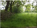
Field and old gate near Taw Green
A riverside field on the west of the valley
Image: © David Smith
Taken: 27 May 2014
0.08 miles
2

Footpath to the River Taw, Taw Green
A well-used footpath from a minor road to the river through the trees on the river bank
Image: © David Smith
Taken: 27 May 2014
0.11 miles
3

Farm buildings at Taw Barton
On the left is a breeze-block wall; just in front are a pair of granite gateposts from an earlier layout of the yard
Image: © David Smith
Taken: 27 May 2014
0.14 miles
4
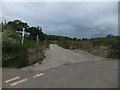
Road junction at Hayrish, west of Taw Green
The signpost is labelled Hayrish Cross
Image: © David Smith
Taken: 27 May 2014
0.14 miles
5
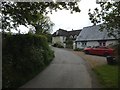
Taw Barton
Farm buildings, including a holiday cottage at Taw Barton
Image: © David Smith
Taken: 27 May 2014
0.14 miles
6
The view downstream from Taw Green Bridge on the river Taw
Image: © Roger A Smith
Taken: 5 May 2010
0.15 miles
7
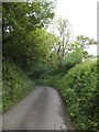
High banks to the road south of Halford
The minor road from Halford to Taw Green runs between high banks, and at the bend, there is a dogleg through a small wood
Image: © David Smith
Taken: 27 May 2014
0.15 miles
8
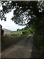
Sheep at Taw Barton
The road north of Taw Barton, passing farm buildings
Image: © David Smith
Taken: 27 May 2014
0.16 miles
9
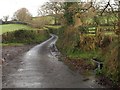
Lane near Taw Green
The lane from Taw Green northwards, which forms a through route between South and North Tawton. On the right is an overflowing water trough.
Image: © Derek Harper
Taken: 9 Dec 2009
0.16 miles
10

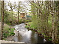
Taw Green Bridge
This C19 bridge across the River Taw (flowing to the right) is described at http://www.imagesofengland.org.uk/Details/Default.aspx?id=95052&mode=adv .
Image: © Derek Harper
Taken: 9 Dec 2009
0.17 miles