
IMAGES TAKEN NEAR TO
South Tawton, OKEHAMPTON, EX20 2LW
Introduction
This page details the photographs taken nearby to EX20 2LW by members of the Geograph project.
The Geograph project started in 2005 with the aim of publishing, organising and preserving representative images for every square kilometre of Great Britain, Ireland and the Isle of Man.

There are currently over 7.5m images from over14,400 individuals and you can help contribute to the project by visiting https://www.geograph.org.uk
Image Map
Images are licensed for reuse under creativecommons.org/licenses/by-sa/2.0
Notes
- Clicking on the map will re-center to the selected point.
- The higher the marker number, the further away the image location is from the centre of the postcode.
Image Listing (45 Images Found)
Images are licensed for reuse under creativecommons.org/licenses/by-sa/2.0
Image
Details
Distance
1

Houses in South Tawton
Houses on the east side of Fore Street, with the thatched C17 Beggars Roost on the left (described at http://www.britishlistedbuildings.co.uk/en-95000-church-view-cottage-and-beggars-roost-sou ) and Victorian cottages above.
Image: © Derek Harper
Taken: 8 Jun 2006
0.00 miles
2
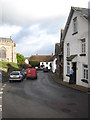
The postman doing his rounds in Fore Street South Tawton
Image: © Rod Allday
Taken: 27 Jan 2012
0.01 miles
3
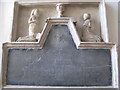
The Burgoyne Monument in St Andrew's Church South Tawton
This slate and stone tablet on the wall of the South Chapel is dated 1651 and is in memory of Robert Burgoyne, his wife and their family. Those who are commemorated include a child in a cradle and an infant in a shroud.
Image: © Rod Allday
Taken: 27 Jan 2012
0.01 miles
4
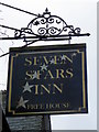
Sign for the Seven Stars
This common name alludes to the seven stars supposedly around the halo of the Virgin Mary.
Image: © Maigheach-gheal
Taken: 15 Feb 2011
0.02 miles
5
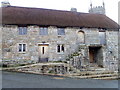
Church House, South Tawton
The late 15th century building is constructed of granite with a thatched roof. Church houses were built in the 15th and 16th centuries as a community building
used for brewing ales, cooking and for social functions and fund-raising. Many
had a short life as such, as at the end of the 16th century brewing and feasting on church property was banned. It has been used as a poor house, a school house, a parish rooms and storage space.
Image: © Maigheach-gheal
Taken: 15 Feb 2011
0.02 miles
6

Lych gate of St. Andrew's church, South Tawton
Seen from inside the churchyard. Church House is to the right, Image, and the Seven Stars public house is the stone building to the left of the lych gate Image
Image: © Richard Dorrell
Taken: 24 Mar 2010
0.02 miles
7
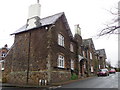
The Seven Stars Inn, South Tawton
Built in the 17th century, the inn is located in the heart of the village, opposite the impressive village Church of St Andrews and the church house.
Image: © Maigheach-gheal
Taken: 15 Feb 2011
0.02 miles
8
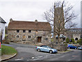
Church House, South Tawton
Church House is a medieval community building. The community of the Parish of South Tawton has used Church House for over 500 years and it is still owned by the Incumbent and Church Wardens, as Trustees on behalf of the Parish and is run by the Church House Management Committee.
More information - http://www.thechurchhouse.org.uk/ .
Image: © Richard Dorrell
Taken: 23 Mar 2010
0.02 miles
9
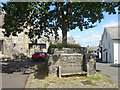
Crosstree, South Tawton
This plinth bears an inscription dating the edifice to the 16ᵗʰC. There are other "crosstrees" notably Colerne which celebrates St Aldhelm. Both villages boast a sizeable church and the crosstrees stand outwith the churchyard.
Inscription:
Cross Tree
a tree has stood here since the days of Queen Elizabeth I
the wall and seat were rebuilt to commemorate the coronation of
Queen Elizabeth II in 1953
Image: © Mr Red
Taken: 6 Aug 2024
0.02 miles
10
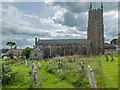
Church of St Andrew
A Grade 1 Listed building with some 15th Century features.
Image: © Guy Wareham
Taken: 2 Sep 2017
0.02 miles