IMAGES TAKEN NEAR TO
South Tawton, OKEHAMPTON, EX20 2LN
Introduction
This page details the photographs taken nearby to EX20 2LN by members of the Geograph project.
The Geograph project started in 2005 with the aim of publishing, organising and preserving representative images for every square kilometre of Great Britain, Ireland and the Isle of Man.

There are currently over 7.5m images from over14,400 individuals and you can help contribute to the project by visiting https://www.geograph.org.uk
Image Map
Images are licensed for reuse under creativecommons.org/licenses/by-sa/2.0
Notes
- Clicking on the map will re-center to the selected point.
- The higher the marker number, the further away the image location is from the centre of the postcode.
Image Listing (4 Images Found)
Images are licensed for reuse under creativecommons.org/licenses/by-sa/2.0
Image
Details
Distance
1
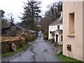
Tawton Mill
Located just east of the village of South Tawton.
Image: © Richard Dorrell
Taken: 23 Mar 2010
0.01 miles
2
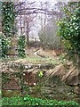
Mill leat at Tawton Mill
The mill is no longer in use, and has been converted into a house, but ponds and this leat still exist.
Image: © Richard Dorrell
Taken: 23 Mar 2010
0.03 miles
3
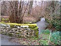
South Tawton mill bridge
The stream is a tributary of the River Taw. The bridge is in the road between South Tawton and Oxenham Cross.
Image: © Richard Dorrell
Taken: 23 Mar 2010
0.03 miles
4
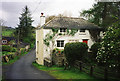
South Tawton: Tawton Mill
Now a private house, the mill retains some of its machinery and had a working waterwheel in 1998
Image: © Martin Bodman
Taken: Unknown
0.07 miles