IMAGES TAKEN NEAR TO
NORTH TAWTON, EX20 2FP
Introduction
This page details the photographs taken nearby to EX20 2FP by members of the Geograph project.
The Geograph project started in 2005 with the aim of publishing, organising and preserving representative images for every square kilometre of Great Britain, Ireland and the Isle of Man.

There are currently over 7.5m images from over14,400 individuals and you can help contribute to the project by visiting https://www.geograph.org.uk
Image Map
Images are licensed for reuse under creativecommons.org/licenses/by-sa/2.0
Notes
- Clicking on the map will re-center to the selected point.
- The higher the marker number, the further away the image location is from the centre of the postcode.
Image Listing (5 Images Found)
Images are licensed for reuse under creativecommons.org/licenses/by-sa/2.0
Image
Details
Distance
1
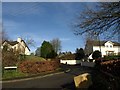
Bouchers Close, North Tawton
A cul-de-sac of modern houses on the north side of town, which also leads to Burton Hall, a house brought here from Norway http://www.britishlistedbuildings.co.uk/en-92973-burton-hall-north-tawton .
Image: © Derek Harper
Taken: 13 Jan 2012
0.16 miles
2

Postbox, North Tawton
George V postbox EX20 111 is at the foot of Bouchers Hill, near the corner of Bouchers Close.
Image: © Derek Harper
Taken: 13 Jan 2012
0.17 miles
3

Footpath and farmland at Bouchers Hill
The footpath is a link from this road to the Devonshire Heartland Way
Image: © David Smith
Taken: 21 Jun 2013
0.23 miles
4
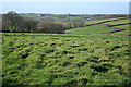
North Tawton: towards Northweek
The farms near the skyline are on the far side of the Taw valley. Looking west
Image: © Martin Bodman
Taken: 14 Feb 2007
0.24 miles
5

Left for a bridleway, right for a footpath, on Wildridge
Image: © David Smith
Taken: 16 Aug 2013
0.25 miles