IMAGES TAKEN NEAR TO
NORTH TAWTON, EX20 2DW
Introduction
This page details the photographs taken nearby to EX20 2DW by members of the Geograph project.
The Geograph project started in 2005 with the aim of publishing, organising and preserving representative images for every square kilometre of Great Britain, Ireland and the Isle of Man.

There are currently over 7.5m images from over14,400 individuals and you can help contribute to the project by visiting https://www.geograph.org.uk
Image Map
Images are licensed for reuse under creativecommons.org/licenses/by-sa/2.0
Notes
- Clicking on the map will re-center to the selected point.
- The higher the marker number, the further away the image location is from the centre of the postcode.
Image Listing (13 Images Found)
Images are licensed for reuse under creativecommons.org/licenses/by-sa/2.0
Image
Details
Distance
1
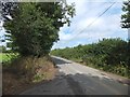
Footpath to West Leigh
The path cuts a corner, missing out the junction at Thorn Corner. The road on the left leads to Ankridge
Image: © David Smith
Taken: 16 Aug 2013
0.07 miles

5

Old Boundary Marker
Parish Boundary Marker sunk in the grass verge beside a fingerpost on the northwest side of the crossroads at Farley's Grave. On the boundary of Zeal Manachorum and Coldridge parishes. Inscribed ZEAL / MONACHORUM and COLD / RIDGE. Grade II Listed details https://historicengland.org.uk/listing/the-list/list-entry/1277820. See also http://www.flickr.com/photos/bridgemarkertim/5330935568/.
Milestone Society National ID: DV_NTHO02pb
Image: © M Hatton
Taken: Unknown
0.17 miles
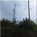
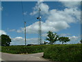
7
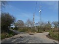
Communications mast at Farley's Grave
Image: © Roger Cornfoot
Taken: 23 Mar 2022
0.17 miles
9
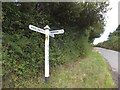
Signpost at Farley's Grave
A strangely named crossroads; there is a fourth road, but it does not merit a finger on the signpost
Image: © David Smith
Taken: 16 Aug 2013
0.18 miles
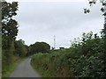
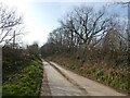
10

Gates near Skinnersland
The road skirts Quarrybank copse on the left, and at the corner there are access gates to two fields. That on the right was given over to vegetables
Image: © David Smith
Taken: 16 Aug 2013
0.18 miles