IMAGES TAKEN NEAR TO
NORTH TAWTON, EX20 2BS
Introduction
This page details the photographs taken nearby to EX20 2BS by members of the Geograph project.
The Geograph project started in 2005 with the aim of publishing, organising and preserving representative images for every square kilometre of Great Britain, Ireland and the Isle of Man.

There are currently over 7.5m images from over14,400 individuals and you can help contribute to the project by visiting https://www.geograph.org.uk
Image Map
Images are licensed for reuse under creativecommons.org/licenses/by-sa/2.0
Notes
- Clicking on the map will re-center to the selected point.
- The higher the marker number, the further away the image location is from the centre of the postcode.
Image Listing (9 Images Found)
Images are licensed for reuse under creativecommons.org/licenses/by-sa/2.0
Image
Details
Distance
3
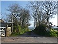
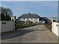
Westacott Barton
The entrance drive down to Westacott Barton
Image: © Jay Pea
Taken: 12 Nov 2017
0.13 miles
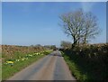
4
North Tawton: above Westacott
Looking south towards Sandford Barton
Image: © Martin Bodman
Taken: 14 Feb 2007
0.17 miles
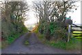
6
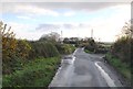
Road junctions
For a minor narrow country lane, there are a lot of crossing and junctions.
Image: © Jay Pea
Taken: 12 Nov 2017
0.22 miles
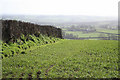
7
North Tawton: Woodcroft
Looking north-north-west
Image: © Martin Bodman
Taken: 14 Feb 2007
0.22 miles
8
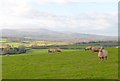
Ruby Red Sheep
The normally white sheep have a reddish hue from coming into contact with the red Devon soil.
Image: © Jay Pea
Taken: 12 Nov 2017
0.23 miles
9
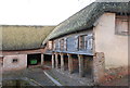
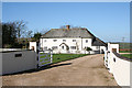
Westacott Barton
One of the traditional farm buildings.
Image: © Jay Pea
Taken: 12 Nov 2017
0.25 miles