IMAGES TAKEN NEAR TO
North Road Industrial Estate, OKEHAMPTON, EX20 1RQ
Introduction
This page details the photographs taken nearby to North Road Industrial Estate, EX20 1RQ by members of the Geograph project.
The Geograph project started in 2005 with the aim of publishing, organising and preserving representative images for every square kilometre of Great Britain, Ireland and the Isle of Man.

There are currently over 7.5m images from over14,400 individuals and you can help contribute to the project by visiting https://www.geograph.org.uk
Image Map (Loading...)


Getting Data...Please wait
Leaflet Map data © OpenStreetMap
Images are licensed for reuse under creativecommons.org/licenses/by-sa/2.0
Notes
- Clicking on the map will re-center to the selected point.
- The higher the marker number, the further away the image location is from the centre of the postcode.
Image Listing (15 Images Found)
Images are licensed for reuse under creativecommons.org/licenses/by-sa/2.0
Image
Details
Distance
1
Quarry entrance, Okehampton
Besides telling passers-by that the quarry is private property, the sign has pictograms for various safety matters on site
Image: © David Smith
Taken: 25 Apr 2013
0.02 miles
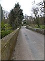
2
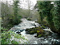
River Okement at Knowle Bridge
Looking south, upstream, towards Okehampton.
Image: © Jonathan Billinger
Taken: 24 Feb 2010
0.05 miles
3
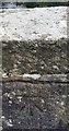
Ordnance Survey Cut Mark
This OS cut mark can be found on the south parapet of Knowle Bridge. It marks a point 138.858m above mean sea level.
Image: © Adrian Dust
Taken: 29 Mar 2019
0.09 miles
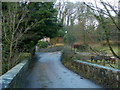
4
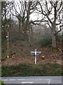
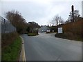
Signpost at Knowle Cross
The road across the picture runs along the river valley. Behind the sign the ground rises away from the flood plain.
Image: © David Smith
Taken: 25 Apr 2013
0.09 miles
6
Road to East and West Hook
The road climbs the steep west side of the Okement valley to the north of Okehampton.
Image: © Jonathan Billinger
Taken: 24 Feb 2010
0.10 miles
7

PoleStar Foods factory, North Road, Okehampton
The company has been forged out of the purchase in 2009 of two of Heinz' frozen desserts factories, the other one situated in Leamington Spa.
Image: © Jonathan Billinger
Taken: 24 Feb 2010
0.13 miles
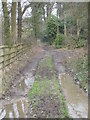
8

Abbeyford Woods
A gentle section of Tarka Trail through Abbeyford Woods.
Image: © Grant Sherman
Taken: 17 Nov 2005
0.18 miles
9
Track leading from Oaklands to Knowle Bridge
Image: © Rod Allday
Taken: 31 Jan 2009
0.18 miles
10

Okehampton: site of Roman fort
Looking north west. The fort was constructed in the period after AD 50 and is thought to be contemporary with a legionary fortress at Exeter. Its main axis is aligned north-north-east and it may have stood on the Roman road from Exeter to the west, which ran by a larger establishment at North Tawton. See also: Francis Griffith, Devon’s Past: An Aerial View. Devon Books 1988, 50. The fort was discovered on an aerial photograph in 1975
A Roman road running eastwards from the fort to the next military base towards Exeter, at North Tawton, was discovered circa 2013 during an archaeological dig in advance of proposed residential expansion at Okehampton. It links to the east gate of the fort at Chichacott Lane and was found to be eight metres wide.
The fort was garrisoned between AD50 and AD85.
[Source: Devon Archaeological Society Newsletter 118, April 2014]
Image: © Martin Bodman
Taken: 10 Oct 2007
0.21 miles