IMAGES TAKEN NEAR TO
Darkey Lane, OKEHAMPTON, EX20 1JL
Introduction
This page details the photographs taken nearby to Darkey Lane, EX20 1JL by members of the Geograph project.
The Geograph project started in 2005 with the aim of publishing, organising and preserving representative images for every square kilometre of Great Britain, Ireland and the Isle of Man.

There are currently over 7.5m images from over14,400 individuals and you can help contribute to the project by visiting https://www.geograph.org.uk
Image Map (Loading...)


Getting Data...Please wait
Leaflet Map data © OpenStreetMap
Images are licensed for reuse under creativecommons.org/licenses/by-sa/2.0
Notes
- Clicking on the map will re-center to the selected point.
- The higher the marker number, the further away the image location is from the centre of the postcode.
Image Listing (178 Images Found)
Images are licensed for reuse under creativecommons.org/licenses/by-sa/2.0
Image
Details
Distance
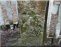
1

Ordnance Survey Cut Mark
This OS cut mark can be found on gatepost at the rear of Gloucester Lodge, Church Street. It marks a point 149.994m above mean sea level.
Image: © Adrian Dust
Taken: 30 Mar 2019
0.06 miles
4

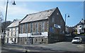
Ordnance Survey 1GL Bolt
This OS Bolt can be found on the NE face of the Chapel. It marks a point 154.053m above mean sea level.
Image: © Adrian Dust
Taken: 30 Mar 2019
0.09 miles

8
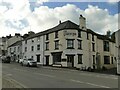
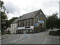
The London Inn, Okehampton
The signage has changed since 2014 Image Beyond it is the Plymouth Inn Image; the road through Okehampton was one of the principal routes between the two cities.
Image: © Stephen Craven
Taken: 20 Oct 2022
0.10 miles
9
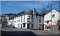
Ordnance Survey Cut Mark
This OS cut mark can be found on the gatepost at the junction of Church Avenue & Vicarage Road. It marks a point 181.860m above mean sea level.
Image: © Adrian Dust
Taken: 30 Mar 2019
0.10 miles
10
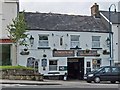
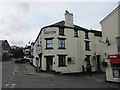
Plymouth Inn, Okehampton
This old coaching inn serves good beer and has a lively, friendly atmosphere--the bar was full at 4:30 p.m. on a Monday.
On prominent display was a poster listing the people who had been banned from this pub and other pubs in Okehampton, and warning that anyone found to be buying these individuals a drink risked being banned too.
Image: © Mike White
Taken: 18 Aug 2008
0.11 miles