IMAGES TAKEN NEAR TO
Castle Lane, OKEHAMPTON, EX20 1JA
Introduction
This page details the photographs taken nearby to Castle Lane, EX20 1JA by members of the Geograph project.
The Geograph project started in 2005 with the aim of publishing, organising and preserving representative images for every square kilometre of Great Britain, Ireland and the Isle of Man.

There are currently over 7.5m images from over14,400 individuals and you can help contribute to the project by visiting https://www.geograph.org.uk
Image Map (Loading...)


Getting Data...Please wait
Leaflet Map data © OpenStreetMap
Images are licensed for reuse under creativecommons.org/licenses/by-sa/2.0
Notes
- Clicking on the map will re-center to the selected point.
- The higher the marker number, the further away the image location is from the centre of the postcode.
Image Listing (46 Images Found)
Images are licensed for reuse under creativecommons.org/licenses/by-sa/2.0
Image
Details
Distance
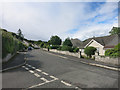
1
Terrace of houses, glimpsed from east of the river, at Okehampton
Image: © Roger Cornfoot
Taken: 3 Jul 2010
0.01 miles
2
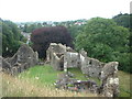
Okehampton Castle
Near the south of the square.
Image: © Chris Shaw
Taken: Unknown
0.03 miles
3
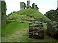
Okehampton Castle 'motte'
This is the 'motte' of Okehampton castle. A motte is an enditched mound, usually artificial, which supported the strongpoint of the motte-and-bailey castle, overshadowing the bailey or enclosed courtyard below. The castle was built in as a 'chivalric' type castle. ie: it was built by a rich lord to impress his friends and the local populace with his knightly castle. As it never actually saw any action, or was ever defended. First mentioned in the Domesday Book as the first castle to be built at Okehampton, by the Sheriff of Devon, during the late 11th century. The castle was largely abandoned in 1539 after its owner, Henry, Marquis of Exeter, was found guilty of conspiracy and executed by Henry VIII.
Image: © doc
Taken: 21 Jul 2005
0.03 miles
4

Okehampton Castle
Wonderful old castle on the edge of Okehampton.
Image: © john spivey
Taken: 23 Aug 2002
0.03 miles
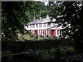
5
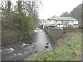
Houses beside the River Okement
Seen from Castle Lane.
Image: © John Baker
Taken: 26 Mar 2013
0.03 miles
6
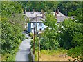
Castle Lane
Seen from the castle mound, there are a number of terraced dwellings set at right angles to the lane.
Image: © mike smith
Taken: 7 Aug 2013
0.06 miles
7
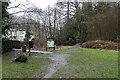
Two Castles Trail leading into Okehampton
Image: © John Lucas
Taken: 9 Feb 2022
0.08 miles
8

River Okement
There is a riverside picnic area and woodland walks in this area near Okehampton Castle.
Image: © mike smith
Taken: 7 Aug 2013
0.10 miles
9
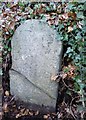
Old Boundary Marker by the B3260, New Road, Okehampton
Parish Boundary Marker by the B3260 (was A30), in parish of Okehampton (West Devon District), New Road, 250m South of Prospect Hill, in steep bank, just above road edge, Northwest side of road.
Devon & Dartmoor HER.
HER Number: MDV59502 https://www.heritagegateway.org.uk/Gateway/Results_Single.aspx?uid=MDV59502&resourceID=104
Surveyed
Milestone Society National ID: DV_LAEX15pb
Image: © Alan Rosevear
Taken: 18 Feb 2013
0.10 miles