IMAGES TAKEN NEAR TO
Summering Close, OKEHAMPTON, EX20 1FX
Introduction
This page details the photographs taken nearby to Summering Close, EX20 1FX by members of the Geograph project.
The Geograph project started in 2005 with the aim of publishing, organising and preserving representative images for every square kilometre of Great Britain, Ireland and the Isle of Man.

There are currently over 7.5m images from over14,400 individuals and you can help contribute to the project by visiting https://www.geograph.org.uk
Image Map
Images are licensed for reuse under creativecommons.org/licenses/by-sa/2.0
Notes
- Clicking on the map will re-center to the selected point.
- The higher the marker number, the further away the image location is from the centre of the postcode.
Image Listing (10 Images Found)
Images are licensed for reuse under creativecommons.org/licenses/by-sa/2.0
Image
Details
Distance
1

New unit at Hameldown Business Park, Okehampton
Looking north on Galbraith Road.
Image: © Jonathan Billinger
Taken: 9 Dec 2008
0.11 miles
2

Robert Wiseman Dairy, Okehampton
Part of a company supplying fresh milk products to multiples and independents alike.
Image: © Jonathan Billinger
Taken: 9 Dec 2008
0.11 miles
3

Business at Hameldown Park, Okehampton
A recently created industrial area to the east of the town.
Image: © Jonathan Billinger
Taken: 9 Dec 2008
0.13 miles
4
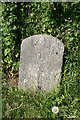
Old Milestone by the B3260, Exeter Road, Okehampton Hamlets
Carved stone post by the B3260 (was A30), in parish of OKEHAMPTON HAMLETS (WEST DEVON District), Exeter Road, junction with Beardown Road, by Business Park, on grass verge at corner, on North side of road. Okehampton tombstone, erected by the Okehampton turnpike trust in the 18th century.
Inscription reads:-
OKEHAMPTON
1
MILE
Devon & Dartmoor HER listed.
HER Number: MDV71822 https://www.heritagegateway.org.uk/Gateway/Results_Single.aspx?uid=MDV71822&resourceID=104
Milestone Society National ID: DV_EXOK21.
Image: © Alan Rosevear
Taken: 20 Apr 2011
0.19 miles
5

Old railway bridge off Hameldown Road
The bridge has become redundant since Hameldown Road was built as part of a modern industrial estate, cutting off the access at this western end.
Image: © Rod Allday
Taken: 1 Jul 2015
0.19 miles
6
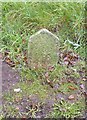
Old Boundary Marker by the B3260, Exeter Road, Okehampton
Parish Boundary Marker by the B3260 (was A30), in parish of Okehampton (West Devon District), Exeter Road; by Trevenn, No. 75, on grass verge by drive, North side of road.
Inscription reads:-
OBB
1935
(Okehampton Borough Bounds)
Devon & Dartmoor HER.
HER Number: MDV59504 https://www.heritagegateway.org.uk/Gateway/Results_Single.aspx?uid=MDV59504&resourceID=104
Surveyed
Milestone Society National ID: DV_LAEX16pb
Image: © Alan Rosevear
Taken: 7 Mar 2013
0.22 miles
7
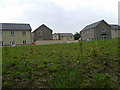
New houses on the east side of Okehampton
Image: © Rob Purvis
Taken: 31 May 2014
0.22 miles
8

New house building on the outskirts of Okehampton
Image: © JThomas
Taken: 9 May 2013
0.23 miles
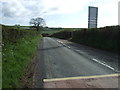
10
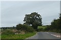
Tree by B3215, edge of Okehampton
The town is expanding along this road; on the left is a developers' fence
Image: © David Smith
Taken: 2 Sep 2020
0.25 miles