IMAGES TAKEN NEAR TO
Brandize Park, OKEHAMPTON, EX20 1EQ
Introduction
This page details the photographs taken nearby to Brandize Park, EX20 1EQ by members of the Geograph project.
The Geograph project started in 2005 with the aim of publishing, organising and preserving representative images for every square kilometre of Great Britain, Ireland and the Isle of Man.

There are currently over 7.5m images from over14,400 individuals and you can help contribute to the project by visiting https://www.geograph.org.uk
Image Map (Loading...)


Getting Data...Please wait
Leaflet Map data © OpenStreetMap
Images are licensed for reuse under creativecommons.org/licenses/by-sa/2.0
Notes
- Clicking on the map will re-center to the selected point.
- The higher the marker number, the further away the image location is from the centre of the postcode.
Image Listing (134 Images Found)
Images are licensed for reuse under creativecommons.org/licenses/by-sa/2.0
Image
Details
Distance
1

Horse trough and public fountain, Okehampton
Donated to the town in 1895, convenient for horse-drawn vehicles going to and from the nearby railway station
Image: © David Smith
Taken: 19 Feb 2020
0.05 miles
2
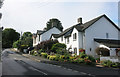
Tors Road, Okehampton
Climbing up from the town centre, Tors Road eventually ends up at a military camp on the edge of Dartmoor.
Image: © Des Blenkinsopp
Taken: 28 Aug 2016
0.06 miles
3

Pillar box on Station Road, Okehampton
See Image for context.
Image: © Stephen Craven
Taken: 20 Oct 2022
0.07 miles
4

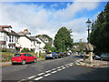
Station Road, Okehampton
Station Road branches to the left, Tors Road is straight ahead. Station Road is again correctly named now the railway to Okehampton has reopened. Part of the steep walk from Okehampton town centre to the station. Okehampton war memorial is in the centre of the junction.
Image: © John Lucas
Taken: 25 Nov 2021
0.07 miles
5
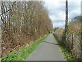
On the Granite Way cycle route, looking towards Okehampton railway station
Image: © Rob Purvis
Taken: 27 Apr 2013
0.07 miles
6
Drinking Fountain, Station Road
Okehampton Station is very much on the edge of town and it's quite a steep walk up from the town centre.
This fountain at the junction of Station Road with Tors Road is about half way up the hill and a quick slurp was probably appreciated on a hot day.
Image: © Des Blenkinsopp
Taken: 28 Aug 2016
0.07 miles
7
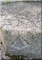
Ordnance Survey Rivet
This damaged OS rivet can be found on the water fountain at the junction of Station Road & Park Road. It marks a point 187.391m above mean sea level.
Image: © Adrian Dust
Taken: 31 Mar 2019
0.07 miles
8

Combined lamp, trough and drinking fountain
One piece of street furniture serving a variety of purposes. The road to the right leads to Okehampton Station.
Image: © David Smith
Taken: 27 Aug 2010
0.07 miles
9
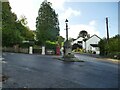
Junction of Station Road and Tors Road
Note the unusual lamp and drinking fountain in the centre of the triangular junction Image
Image: © Stephen Craven
Taken: 20 Oct 2022
0.08 miles
10
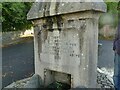
Drinking trough detail
The structure at the junction of Station Road and Tors Road bears a date of 1895. See Image for context.
Image: © Stephen Craven
Taken: 20 Oct 2022
0.08 miles