IMAGES TAKEN NEAR TO
Fairplace Terrace, OKEHAMPTON, EX20 1DT
Introduction
This page details the photographs taken nearby to Fairplace Terrace, EX20 1DT by members of the Geograph project.
The Geograph project started in 2005 with the aim of publishing, organising and preserving representative images for every square kilometre of Great Britain, Ireland and the Isle of Man.

There are currently over 7.5m images from over14,400 individuals and you can help contribute to the project by visiting https://www.geograph.org.uk
Image Map
Images are licensed for reuse under creativecommons.org/licenses/by-sa/2.0
Notes
- Clicking on the map will re-center to the selected point.
- The higher the marker number, the further away the image location is from the centre of the postcode.
Image Listing (232 Images Found)
Images are licensed for reuse under creativecommons.org/licenses/by-sa/2.0
Image
Details
Distance
2
Cafe and Arcade, St James Street, Okehampton
The arcade was built in 1896 on the site of Savile House
Image: © Stephen Craven
Taken: 20 Oct 2022
0.02 miles
4
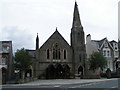
Fairplace United Church
Dates from 1904 and built as a Wesleyan Methodist Chapel.
Image: © Jonathan Thacker
Taken: 18 Sep 2017
0.02 miles
5
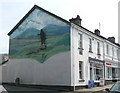
Mural, Park Row, Okehampton
This has a three-dimensional sculpted figure of a hiker, standing on a rock, in front of a mural painting of Dartmoor.
Image: © Humphrey Bolton
Taken: 10 Apr 2010
0.02 miles
7
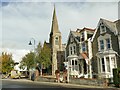
Fairplace United Church, Okehampton
A former Wesleyan Methodist church of 1903, since 1974 sharing the building with the United Reformed Church (itself a union of Presbyterians and Congregationalists).
Image: © Stephen Craven
Taken: 20 Oct 2022
0.03 miles
8
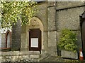
Fairplace United Church, Okehampton - datestone
There is a date of 1903 above the side door. See Image for context.
Image: © Stephen Craven
Taken: 20 Oct 2022
0.03 miles
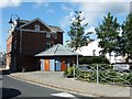
9
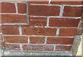
Ordnance Survey Cut Mark
This OS cut mark can be found on the Police Station, George Street. It marks a point 155.690m above mean sea level.
Image: © Adrian Dust
Taken: 30 Mar 2019
0.03 miles
10
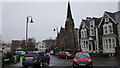
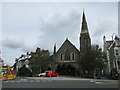
Okehampton : Mill Road
Fairplace United Church can be seen in view here.
Image: © Lewis Clarke
Taken: 18 Mar 2017
0.03 miles