IMAGES TAKEN NEAR TO
Hector Close, WINKLEIGH, EX19 8UD
Introduction
This page details the photographs taken nearby to Hector Close, EX19 8UD by members of the Geograph project.
The Geograph project started in 2005 with the aim of publishing, organising and preserving representative images for every square kilometre of Great Britain, Ireland and the Isle of Man.

There are currently over 7.5m images from over14,400 individuals and you can help contribute to the project by visiting https://www.geograph.org.uk
Image Map
Images are licensed for reuse under creativecommons.org/licenses/by-sa/2.0
Notes
- Clicking on the map will re-center to the selected point.
- The higher the marker number, the further away the image location is from the centre of the postcode.
Image Listing (58 Images Found)
Images are licensed for reuse under creativecommons.org/licenses/by-sa/2.0
Image
Details
Distance
1
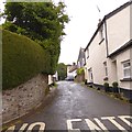
Chapel Street, Dolton
The Baptist chapel is part way up the street on the right
Image: © David Smith
Taken: 14 Jul 2015
0.03 miles
2
Rectory Road (B3217) in Dolton
Mixed thatch and tiled roofs
Image: © David Smith
Taken: 14 Jul 2015
0.04 miles
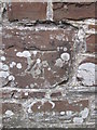
3

Ordnance Survey Cut Mark
This OS cut mark can be found on the wall of Cross Cottage, Rectory Road. It marks a point 116.229m above mean sea level.
Image: © Adrian Dust
Taken: 5 Sep 2015
0.04 miles
5
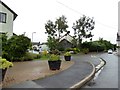
The Paddocks, Dolton
A small modern estate in the centre of the village
Image: © David Smith
Taken: 14 Jul 2015
0.07 miles
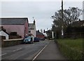
6

Stafford Way
A modern estate on the east of Dolton
Image: © David Smith
Taken: 16 Feb 2012
0.08 miles
7
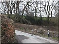
The bridge in Brook Road
The road crosses a small stream at the north of the village
Image: © David Smith
Taken: 16 Feb 2012
0.11 miles
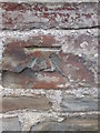
8
Ordnance Survey Cut Mark
This OS cut mark can be found on the wall, SE side of the South Street. It marks a point 116.724m above mean sea level.
Image: © Adrian Dust
Taken: 5 Sep 2015
0.11 miles
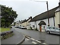
9
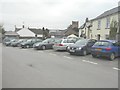
The Square, Dolton
With the tower of St Edmund's church in the background.
Image: © John Baker
Taken: 25 Mar 2013
0.12 miles
10
Ordnance Survey Cut Mark
This damaged OS cut mark can be found on a roadside building at Barland's Farm. It marks a point 126.477m above mean sea level.
Image: © Adrian Dust
Taken: 5 Sep 2015
0.13 miles