IMAGES TAKEN NEAR TO
Roborough, WINKLEIGH, EX19 8TZ
Introduction
This page details the photographs taken nearby to EX19 8TZ by members of the Geograph project.
The Geograph project started in 2005 with the aim of publishing, organising and preserving representative images for every square kilometre of Great Britain, Ireland and the Isle of Man.

There are currently over 7.5m images from over14,400 individuals and you can help contribute to the project by visiting https://www.geograph.org.uk
Image Map
Images are licensed for reuse under creativecommons.org/licenses/by-sa/2.0
Notes
- Clicking on the map will re-center to the selected point.
- The higher the marker number, the further away the image location is from the centre of the postcode.
Image Listing (8 Images Found)
Images are licensed for reuse under creativecommons.org/licenses/by-sa/2.0
Image
Details
Distance
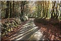
1
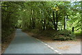
Lane to Ebberly Cross
The lane from Ten Oaks, about to enter the woodland that surrounds the junction.
Image: © Derek Harper
Taken: 30 Nov 2016
0.18 miles
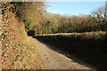
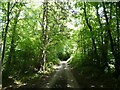
2
Lane near Ebberly Cross
Passing through Home Copse in a tributary valley of the Woolleigh Brook.
Image: © Derek Harper
Taken: 30 Nov 2016
0.20 miles
3
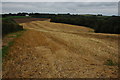
Stubble field near Ebberly
Partly ploughed stubble field above Wansleyhill Wood which can be seen on the right. Ebberly House can be seen in the background.
Image: © Philip Halling
Taken: 9 Sep 2007
0.21 miles
4
Ebberly Cross
Ebberly Cross is actually a T-junction.
Image: © Philip Halling
Taken: 9 Sep 2007
0.21 miles
5
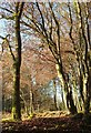
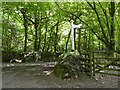
Trees, Ebberly Cross
Looking across the angle of woodland between the lanes at the junction shown in
Image
Image: © Derek Harper
Taken: 30 Nov 2016
0.21 miles
7
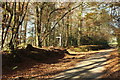
Ebberly Cross
Looking in the opposite direction to Image], to the junction and its signpost.
Image: © Derek Harper
Taken: 30 Nov 2016
0.24 miles