IMAGES TAKEN NEAR TO
WINKLEIGH, EX19 8HA
Introduction
This page details the photographs taken nearby to EX19 8HA by members of the Geograph project.
The Geograph project started in 2005 with the aim of publishing, organising and preserving representative images for every square kilometre of Great Britain, Ireland and the Isle of Man.

There are currently over 7.5m images from over14,400 individuals and you can help contribute to the project by visiting https://www.geograph.org.uk
Image Map (Loading...)


Getting Data...Please wait
Leaflet Map data © OpenStreetMap
Images are licensed for reuse under creativecommons.org/licenses/by-sa/2.0
Notes
- Clicking on the map will re-center to the selected point.
- The higher the marker number, the further away the image location is from the centre of the postcode.
Image Listing (6 Images Found)
Images are licensed for reuse under creativecommons.org/licenses/by-sa/2.0
Image
Details
Distance
1
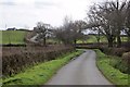
Road past Loosedon Cottages
The road from Loosedon Cross crosses a headwater of the Hollocombe Water and climbs past the cottages towards Loosedon Barton.
Image: © Derek Harper
Taken: 20 Feb 2012
0.09 miles
2
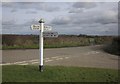
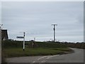
Signpost, Loosedon Barton
Another view of Image The signpost is suffering from letter fatigue; the most serious victim is North Tawton.
Image: © Derek Harper
Taken: 20 Feb 2012
0.14 miles
3
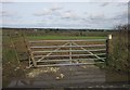
Gate, Loosedon Barton
A large puddle by the lane on the right of Image; the gate is visible in that photo.
Image: © Derek Harper
Taken: 20 Feb 2012
0.15 miles
5
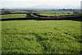
Winkleigh: towards Cosdon
Looking south by the lane to Three-Ways Cross at New Buildings. Cosdon is the Dartmoor hill on the horizon, centre image
Image: © Martin Bodman
Taken: 4 Feb 2007
0.19 miles
6
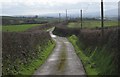
Lane to Three Cross Ways
The lane from Loosedon descends steadily between hedges, with views to Dartmoor ahead.
Image: © Derek Harper
Taken: 20 Feb 2012
0.23 miles