IMAGES TAKEN NEAR TO
Broadwoodkelly, WINKLEIGH, EX19 8EG
Introduction
This page details the photographs taken nearby to EX19 8EG by members of the Geograph project.
The Geograph project started in 2005 with the aim of publishing, organising and preserving representative images for every square kilometre of Great Britain, Ireland and the Isle of Man.

There are currently over 7.5m images from over14,400 individuals and you can help contribute to the project by visiting https://www.geograph.org.uk
Image Map (Loading...)


Getting Data...Please wait
Leaflet Map data © OpenStreetMap
Images are licensed for reuse under creativecommons.org/licenses/by-sa/2.0
Notes
- Clicking on the map will re-center to the selected point.
- The higher the marker number, the further away the image location is from the centre of the postcode.
Image Listing (5 Images Found)
Images are licensed for reuse under creativecommons.org/licenses/by-sa/2.0
Image
Details
Distance
1
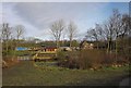
Southdown Farm
Seen from the lane from Exbourne. The farm is in a tributary valley of the Hole Brook.
Image: © Derek Harper
Taken: 20 Feb 2012
0.04 miles
2
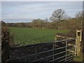
Field at Southdown
From the spot where Image was taken, looking to the left.
Image: © Derek Harper
Taken: 20 Feb 2012
0.10 miles
3
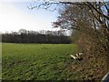
Field by Alchey Down
Taken from the gate shown in Image; the farm road to Alchey Down runs along the right side of the field.
Image: © Derek Harper
Taken: 20 Feb 2012
0.23 miles
4
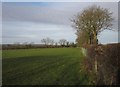
Field by Southdown Cross
This view is on the other side of the farm road to Alchey Down to the one shown in Image, and is to the left of the view in Image
Image: © Derek Harper
Taken: 20 Feb 2012
0.23 miles
5

Broadwoodkelly: Southdown Cross
The left turn leads to Coxwell and Exbourne. Looking west-north-west
Image: © Martin Bodman
Taken: 4 Feb 2007
0.24 miles