IMAGES TAKEN NEAR TO
Broadwoodkelly, WINKLEIGH, EX19 8BU
Introduction
This page details the photographs taken nearby to EX19 8BU by members of the Geograph project.
The Geograph project started in 2005 with the aim of publishing, organising and preserving representative images for every square kilometre of Great Britain, Ireland and the Isle of Man.

There are currently over 7.5m images from over14,400 individuals and you can help contribute to the project by visiting https://www.geograph.org.uk
Image Map
Images are licensed for reuse under creativecommons.org/licenses/by-sa/2.0
Notes
- Clicking on the map will re-center to the selected point.
- The higher the marker number, the further away the image location is from the centre of the postcode.
Image Listing (5 Images Found)
Images are licensed for reuse under creativecommons.org/licenses/by-sa/2.0
Image
Details
Distance
1
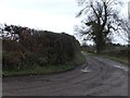
The access track to Lower Ingley (or Ingleigh)
Image: © David Smith
Taken: 16 Feb 2012
0.05 miles
2
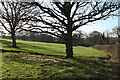
Broadwoodkelly: near Oakley House
Looking west-south-west
Image: © Martin Bodman
Taken: 4 Feb 2007
0.17 miles
3
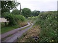
Lane near Chubhouse Farm
A small lane with grass down the middle, which connects Three Cross Ways and Loosedon Cross, bends as it briefly crosses into this square. See Image] for virtually the same view six years on.
Image: © Derek Harper
Taken: 28 Jun 2007
0.18 miles
4

Lane near Chubhouse Farm
The view shown in Image nearly six years later, and without leaves on the trees.
Image: © Derek Harper
Taken: 19 Apr 2013
0.18 miles
5
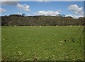
Sheep near Chubhouse Farm
From the top of the bank beside Image The trees are along a tributary of the River Okement. Beyond is Chapple Copse.
Image: © Derek Harper
Taken: 19 Apr 2013
0.24 miles