IMAGES TAKEN NEAR TO
Beaford, WINKLEIGH, EX19 8AH
Introduction
This page details the photographs taken nearby to EX19 8AH by members of the Geograph project.
The Geograph project started in 2005 with the aim of publishing, organising and preserving representative images for every square kilometre of Great Britain, Ireland and the Isle of Man.

There are currently over 7.5m images from over14,400 individuals and you can help contribute to the project by visiting https://www.geograph.org.uk
Image Map
Images are licensed for reuse under creativecommons.org/licenses/by-sa/2.0
Notes
- Clicking on the map will re-center to the selected point.
- The higher the marker number, the further away the image location is from the centre of the postcode.
Image Listing (11 Images Found)
Images are licensed for reuse under creativecommons.org/licenses/by-sa/2.0
Image
Details
Distance
1
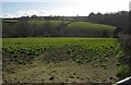
Beaford Brook valley
Seen from the same point as Image], looking to the left. The church spire at Beaford is among trees on the horizon towards the left.
Image: © Derek Harper
Taken: 19 Apr 2013
0.10 miles
2
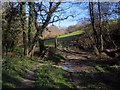
Footpath to Beaford
Beaford Footpath 5 leaves the lane to Upcott Barton in rather charming fashion, crossing a tiny stream and turning right up through a belt of woodland (it doesn't go through the gate).
Image: © Derek Harper
Taken: 19 Apr 2013
0.11 miles
3

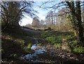
Footpath to Beaford
Further up Beaford Footpath 5, shown in Image], as it runs along a small wooded valley.
Image: © Derek Harper
Taken: 19 Apr 2013
0.11 miles
4
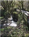
Path near Beaford Brook
A reverse view of Image], as Beaford Footpath 5 crosses a stream and meets the lane to Upcott Barton.
Image: © Derek Harper
Taken: 19 Apr 2013
0.12 miles
5
Beaford Brook
The lane from Upcott Barton crosses the brook among trees.
Image: © Derek Harper
Taken: 19 Apr 2013
0.13 miles
6
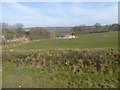
Fields and farm buildings north of Beaford
Image: © David Smith
Taken: 21 Mar 2016
0.15 miles
7
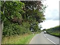
Trees on edge of Yatton Court estate
The entrance to the estate is marked by stone walls opposite the approaching car
Image: © David Smith
Taken: 29 Jul 2020
0.16 miles
8
Old Milestone by the A3124, near Yatton Court, Beaford parish
Carved stone post by the A3124, in parish of BEAFORD (TORRIDGE District), 5m East of drive to Yatton Court, in hedge bank, on North side of road. Torrington wedge, erected by the Great Torrington turnpike trust in the 19th century.
Inscription reads:-
: 29 / Miles / EXON / - : : 5 / Miles / Torrington / - :
Grade II listed.
List Entry Number: 1105064 https://historicengland.org.uk/listing/the-list/list-entry/1105064
Milestone Society National ID: DV_GTEX05.
Image: © A Rosevear
Taken: 2 Feb 2012
0.16 miles
9
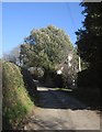
Lane past Cooksworthy
The lane is to Upcott Barton. The C18 thatched cottage is listed http://list.english-heritage.org.uk/resultsingle.aspx?uid=1105062&searchtype=mapsearch .
Image: © Derek Harper
Taken: 19 Apr 2013
0.16 miles
