IMAGES TAKEN NEAR TO
Beaford, WINKLEIGH, EX19 8AD
Introduction
This page details the photographs taken nearby to EX19 8AD by members of the Geograph project.
The Geograph project started in 2005 with the aim of publishing, organising and preserving representative images for every square kilometre of Great Britain, Ireland and the Isle of Man.

There are currently over 7.5m images from over14,400 individuals and you can help contribute to the project by visiting https://www.geograph.org.uk
Image Map
Images are licensed for reuse under creativecommons.org/licenses/by-sa/2.0
Notes
- Clicking on the map will re-center to the selected point.
- The higher the marker number, the further away the image location is from the centre of the postcode.
Image Listing (3 Images Found)
Images are licensed for reuse under creativecommons.org/licenses/by-sa/2.0
Image
Details
Distance
1
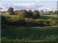
Cannsdown and Brealeys
A view across a valley from Beaford Footpath 8 near Abbot's Hill. Cannsdown House is on the left and buildings at Brealeys to the right. The trees in the centre mark the lane climbing from the valley.
Image: © Derek Harper
Taken: 26 Sep 2007
0.08 miles
2
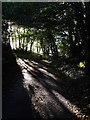
Lane at Abbot's Hill
The little lane is completely enclosed by trees as it climbs from Cannsdown to swing round two sharp left corners, of which this is the first.
Image: © Derek Harper
Taken: 26 Sep 2007
0.10 miles
3
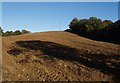
Ploughed field at Abbot's Hill
A field on the slopes of the Torridge valley, occupying part of a narrow ridge between large incised meanders of the river. Abbot's Hill Wood, to the right, plunges 60 metres to the river.
Image: © Derek Harper
Taken: 26 Sep 2007
0.20 miles