IMAGES TAKEN NEAR TO
Wembworthy, CHULMLEIGH, EX18 7SW
Introduction
This page details the photographs taken nearby to EX18 7SW by members of the Geograph project.
The Geograph project started in 2005 with the aim of publishing, organising and preserving representative images for every square kilometre of Great Britain, Ireland and the Isle of Man.

There are currently over 7.5m images from over14,400 individuals and you can help contribute to the project by visiting https://www.geograph.org.uk
Image Map
Images are licensed for reuse under creativecommons.org/licenses/by-sa/2.0
Notes
- Clicking on the map will re-center to the selected point.
- The higher the marker number, the further away the image location is from the centre of the postcode.
Image Listing (7 Images Found)
Images are licensed for reuse under creativecommons.org/licenses/by-sa/2.0
Image
Details
Distance
1
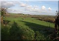
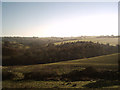
Taw valley near Taw Green
The view looking in a different direction from the spot on Tawgreen Lane where Image was taken. A field slopes down to the Taw valley which broadens out at this point before the river passes through the constriction in the distance (right of centre) at Westacott Wood. What look like woods on the right are merely lines of trees along field boundaries.
Image: © Derek Harper
Taken: 13 Jan 2012
0.12 miles
2
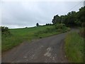
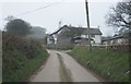
Field at a bend in the road at Taw Green
Image: © David Smith
Taken: 21 Jun 2013
0.20 miles
3
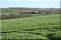
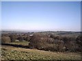
Winkleigh: by Taw Green
Looking south-south-east towards Millsome
Image: © Martin Bodman
Taken: 14 Feb 2007
0.20 miles
6
View of Millsome Castle from Taw Green
Taken on the Tarka Trail. The site of Millsome Castle is actually in Image
Image: © Grant Sherman
Taken: 23 Nov 2005
0.25 miles
7
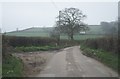
Farmland near Taw Green
Taken on the Tarka Trail
Image: © Grant Sherman
Taken: 23 Nov 2005
0.25 miles