IMAGES TAKEN NEAR TO
Little Meadow, CHULMLEIGH, EX18 7SP
Introduction
This page details the photographs taken nearby to Little Meadow, EX18 7SP by members of the Geograph project.
The Geograph project started in 2005 with the aim of publishing, organising and preserving representative images for every square kilometre of Great Britain, Ireland and the Isle of Man.

There are currently over 7.5m images from over14,400 individuals and you can help contribute to the project by visiting https://www.geograph.org.uk
Image Map
Images are licensed for reuse under creativecommons.org/licenses/by-sa/2.0
Notes
- Clicking on the map will re-center to the selected point.
- The higher the marker number, the further away the image location is from the centre of the postcode.
Image Listing (8 Images Found)
Images are licensed for reuse under creativecommons.org/licenses/by-sa/2.0
Image
Details
Distance
1
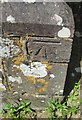
Ordnance Survey Cut Mark
This OS cut mark can be found on the south face of St Michael's Church. It marks a point 151.804m above mean sea level.
Image: © Adrian Dust
Taken: 6 Jul 2016
0.03 miles
2

Wow! a bus shelter in rural Devon
Wembworthy.
Image: © Fernweh
Taken: 15 Mar 2014
0.04 miles
3

St Michael's church, Wembworthy
The battlemented tower dates from 1626, as evidenced by inscriptions beside a window. This view is across the churchyard from the southwest.
Image: © Derek Harper
Taken: 2 Jun 2007
0.04 miles

6
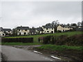
Houses backing on a field in Wembworthy
Image: © Sarah Charlesworth
Taken: 23 Feb 2011
0.14 miles
7

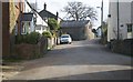
Road junction at Blackhorse Corner, Wembworthy
Looking east to the village
Image: © David Smith
Taken: 15 Sep 2016
0.14 miles
8

Signpost at Blackhorse Corner, Wembworthy
Also named as Black Horse Corner on OS maps; a forth arm of the junction is unsigned, as it is a track and footpath
Image: © David Smith
Taken: 15 Sep 2016
0.16 miles