IMAGES TAKEN NEAR TO
Wembworthy, CHULMLEIGH, EX18 7SJ
Introduction
This page details the photographs taken nearby to EX18 7SJ by members of the Geograph project.
The Geograph project started in 2005 with the aim of publishing, organising and preserving representative images for every square kilometre of Great Britain, Ireland and the Isle of Man.

There are currently over 7.5m images from over14,400 individuals and you can help contribute to the project by visiting https://www.geograph.org.uk
Image Map
Images are licensed for reuse under creativecommons.org/licenses/by-sa/2.0
Notes
- Clicking on the map will re-center to the selected point.
- The higher the marker number, the further away the image location is from the centre of the postcode.
Image Listing (9 Images Found)
Images are licensed for reuse under creativecommons.org/licenses/by-sa/2.0
Image
Details
Distance
1
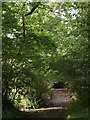
Track to Batelease
A muddy track through trees, seen from Tomsclose Lane (Brushford Bridleway 2). The farm at Batelease is more conventionally reached by another route, a track which leaves Tomsclose Lane up the hill to the east towards Brushford Cross. On the left through the sunlit gap is a field bordering a tributary of the Bullow Brook.
Image: © Derek Harper
Taken: 28 Jun 2007
0.08 miles
2
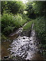
Tomsclose Lane
The track, followed by Brushford Bridleway 2, fords the Bullow Brook tributary mentioned in Image The stile 25 metres ahead takes Brushford Footpath 4 up the valley slope across a field on the left; the track climbs steeply to the right.
Image: © Derek Harper
Taken: 28 Jun 2007
0.10 miles
3
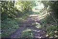
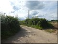
Ford at Brushford Cross
This ford is found on a byway leading from Brushford Cross to West Brushford Farm.
Image: © John Walton
Taken: 21 Sep 2014
0.11 miles
4
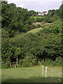
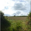
West Brushford Farm
In the foreground, Brushford Footpath 4 descends a steep field to join Image (the stile appears in both photos). The lane can be seen curving gently to the right; it then turns left to reach the farm.
Image: © Derek Harper
Taken: 28 Jun 2007
0.15 miles
5
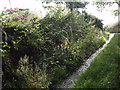
Foxgloves on Tomsclose Lane
Heavy rain has taken its toll of these foxgloves by the bridleway shown in Image
Image: © Derek Harper
Taken: 28 Jun 2007
0.17 miles
6
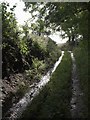
Tomsclose Lane
A steep climb nears its end as the lane, which carries Brushford Bridleway 2 and is here concreted, approaches the junction with the track to Batelease on the right.
Image: © Derek Harper
Taken: 28 Jun 2007
0.18 miles
9
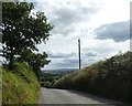
Looking south from Brushford Cross towards Dartmoor
Image: © David Smith
Taken: 29 Jul 2020
0.24 miles