IMAGES TAKEN NEAR TO
Wembworthy, CHULMLEIGH, EX18 7SF
Introduction
This page details the photographs taken nearby to EX18 7SF by members of the Geograph project.
The Geograph project started in 2005 with the aim of publishing, organising and preserving representative images for every square kilometre of Great Britain, Ireland and the Isle of Man.

There are currently over 7.5m images from over14,400 individuals and you can help contribute to the project by visiting https://www.geograph.org.uk
Image Map
Images are licensed for reuse under creativecommons.org/licenses/by-sa/2.0
Notes
- Clicking on the map will re-center to the selected point.
- The higher the marker number, the further away the image location is from the centre of the postcode.
Image Listing (7 Images Found)
Images are licensed for reuse under creativecommons.org/licenses/by-sa/2.0
Image
Details
Distance


4
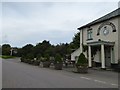
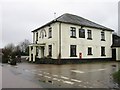
Lymington Arms and its car park at Lama Cross
Patrons can sit outside the front of the inn, protected from the traffic on the quiet road by the half barrels planted with small trees
Image: © David Smith
Taken: 15 Sep 2016
0.15 miles
7

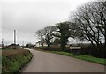
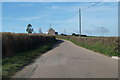
Abbotsham Moor
A small area of open land crossed by footpaths, seen here from the lane between Partridge Walls Cross and Lama Cross.
Image: © Derek Harper
Taken: 2 Jun 2007
0.25 miles