IMAGES TAKEN NEAR TO
Wembworthy, CHULMLEIGH, EX18 7RW
Introduction
This page details the photographs taken nearby to EX18 7RW by members of the Geograph project.
The Geograph project started in 2005 with the aim of publishing, organising and preserving representative images for every square kilometre of Great Britain, Ireland and the Isle of Man.

There are currently over 7.5m images from over14,400 individuals and you can help contribute to the project by visiting https://www.geograph.org.uk
Image Map (Loading...)


Getting Data...Please wait
Leaflet Map data © OpenStreetMap
Images are licensed for reuse under creativecommons.org/licenses/by-sa/2.0
Notes
- Clicking on the map will re-center to the selected point.
- The higher the marker number, the further away the image location is from the centre of the postcode.
Image Listing (6 Images Found)
Images are licensed for reuse under creativecommons.org/licenses/by-sa/2.0
Image
Details
Distance
1
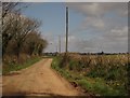
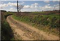
Rashleigh Lane
The track, from Crossgate, leads to Rashleigh Barton. On the right, across the Taw valley, is the church tower at Chulmleigh.
Image: © Derek Harper
Taken: 19 Apr 2013
0.10 miles
2
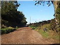
Rashleigh Lane from Crossgate
This track leads to the farm at Rashleigh Barton. For part of its length it follows the ridge of the hilltop before dropping towards the River Taw and the farm
Image: © David Smith
Taken: 15 Oct 2013
0.11 miles
3
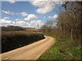
Lane to Bridge Reeve
Curving away from Crossgate, where two tracks form a crossroads. On the right are roadside trees rather than a wood. Down the lane is Western Wood.
Image: © Derek Harper
Taken: 19 Apr 2013
0.13 miles
5
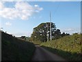
Crossgate crossroads and phone mast
Crossgate is named on maps, but is simply where two farm tracks (not rights of way) meet the minor road. As a convenient high spot in the area, it is a useful site for a phone mast
Image: © David Smith
Taken: 15 Oct 2013
0.14 miles
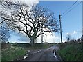
6
Labdon Lane
This lane, opposite the one shown in Image], leads from Crossgate towards Labdon, but in fact only provides field access.
Image: © Derek Harper
Taken: 19 Apr 2013
0.16 miles