IMAGES TAKEN NEAR TO
Chawleigh, CHULMLEIGH, EX18 7HP
Introduction
This page details the photographs taken nearby to EX18 7HP by members of the Geograph project.
The Geograph project started in 2005 with the aim of publishing, organising and preserving representative images for every square kilometre of Great Britain, Ireland and the Isle of Man.

There are currently over 7.5m images from over14,400 individuals and you can help contribute to the project by visiting https://www.geograph.org.uk
Image Map
Images are licensed for reuse under creativecommons.org/licenses/by-sa/2.0
Notes
- Clicking on the map will re-center to the selected point.
- The higher the marker number, the further away the image location is from the centre of the postcode.
Image Listing (3 Images Found)
Images are licensed for reuse under creativecommons.org/licenses/by-sa/2.0
Image
Details
Distance
1
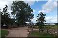
Sheep above West Hill farm
The footpath across this field is part of the Ridge and Valley Walk; it continues to the right of the farm through a small gate
Image: © David Smith
Taken: 6 Aug 2013
0.15 miles
2
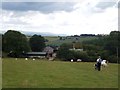
Southcott Farm
The farm buildings are screened by the hedges and trees. The view is from Hilltown Cross. On the horizon at the left is High Willhays on Dartmoor Image
Image: © David Smith
Taken: 6 Aug 2013
0.16 miles