IMAGES TAKEN NEAR TO
South Molton Street, CHULMLEIGH, EX18 7BW
Introduction
This page details the photographs taken nearby to South Molton Street, EX18 7BW by members of the Geograph project.
The Geograph project started in 2005 with the aim of publishing, organising and preserving representative images for every square kilometre of Great Britain, Ireland and the Isle of Man.

There are currently over 7.5m images from over14,400 individuals and you can help contribute to the project by visiting https://www.geograph.org.uk
Image Map (Loading...)


Getting Data...Please wait
Leaflet Map data © OpenStreetMap
Images are licensed for reuse under creativecommons.org/licenses/by-sa/2.0
Notes
- Clicking on the map will re-center to the selected point.
- The higher the marker number, the further away the image location is from the centre of the postcode.
Image Listing (134 Images Found)
Images are licensed for reuse under creativecommons.org/licenses/by-sa/2.0
Image
Details
Distance
1
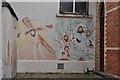
Chulmleigh : Wall Art
A painted picture of Jesus carrying a cross on this wall on a building in Chulmleigh.
Image: © Lewis Clarke
Taken: 1 Jun 2011
0.03 miles
2
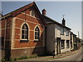
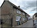
Chapel, Chulmleigh
The "former Methodist Chapel of 1883 in polychrome
brickwork and with a decorative punched barge board on its street facing gable end" http://northdevon-consult.limehouse.co.uk/events/13928/1840866_accessible.pdf . To the right, cottages line South Molton Street.
Image: © Derek Harper
Taken: 22 Aug 2013
0.03 miles
3
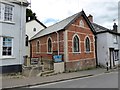
Old Methodist Chapel, Chulmleigh
Now converted into a house; the plaque on the far wall reads "Bethlehem Chapel 1836" and the extension is dated 1883. The agent's particulars record that the conversion has resulted in a cinema room in part of the former worship area
Image: © David Smith
Taken: 7 Aug 2015
0.03 miles
4

Chulmleigh : Royal Charter Park House
A house on Royal Charter Park in Chulmleigh.
Image: © Lewis Clarke
Taken: 1 Jun 2011
0.04 miles
5

Chulmleigh : South Molton Street
Looking down South Molton Street with the Church of Mary Magdalene in the background.
Image: © Lewis Clarke
Taken: 1 Jun 2011
0.04 miles
6
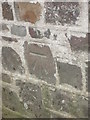
Ordnance Survey Cut Mark
This OS cut mark can be found on the north face of The Old Court House PH. It marks a point 139.717m above mean sea level.
Image: © Adrian Dust
Taken: 28 Nov 2015
0.05 miles
7

The Old Court House, Chulmleigh
This is on South Molton Street and dates from 1633 http://list.english-heritage.org.uk/resultsingle.aspx?uid=1106721&searchtype=mapsearch . Something of the eccentricity of this part of Devon can be gauged from the fact that, as I passed this pub, a man entered followed by his white duck.
Image: © Derek Harper
Taken: 22 Aug 2013
0.05 miles
9
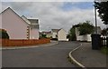
Chulmleigh : Royal Charter Park
Royal Charter Park in Chulmleigh is a road in a residential area.
Image: © Lewis Clarke
Taken: 1 Jun 2011
0.06 miles
