IMAGES TAKEN NEAR TO
Bridge Reeve, CHULMLEIGH, EX18 7BD
Introduction
This page details the photographs taken nearby to EX18 7BD by members of the Geograph project.
The Geograph project started in 2005 with the aim of publishing, organising and preserving representative images for every square kilometre of Great Britain, Ireland and the Isle of Man.

There are currently over 7.5m images from over14,400 individuals and you can help contribute to the project by visiting https://www.geograph.org.uk
Image Map
Images are licensed for reuse under creativecommons.org/licenses/by-sa/2.0
Notes
- Clicking on the map will re-center to the selected point.
- The higher the marker number, the further away the image location is from the centre of the postcode.
Image Listing (25 Images Found)
Images are licensed for reuse under creativecommons.org/licenses/by-sa/2.0
Image
Details
Distance
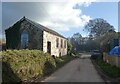
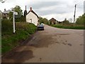
2
Cottages near Kersham Bridge
Cottages near Kersham Bridge in the Taw Valley.
Image: © Philip Halling
Taken: 2 Apr 2006
0.02 miles
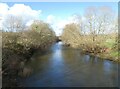
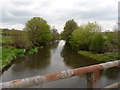
3
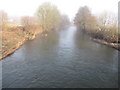
River Taw at Bridge Reeve
The Taw shortly after it has been joined by the Little Dart River
Image: © Dylan Inglis
Taken: 1 Mar 2010
0.04 miles
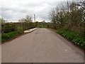
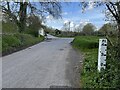
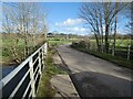
4
A road junction between Cole's Corner and Bridge Reeve Cross
Image: © Roger A Smith
Taken: 11 May 2010
0.04 miles
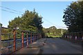
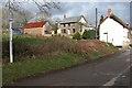
7
Ford at Kersham Bridge
The depth gauges either side of Kersham Bridge mark the fords which arise when the River Taw floods.
Image: © John Walton
Taken: 5 May 2021
0.04 miles
9
The view downstream from Kersham Bridge on the river Taw
Image: © Roger A Smith
Taken: 11 May 2010
0.05 miles